Showing posts with label bush bashing. Show all posts

Thursday, 10 October 2024

Yass District: Bango Nature Reserve

General Information

Grading:  medium
Distance:    9.9 kilometers
Total climb:    416 meters
Time taken:   3 hours 10 minutes
Maps:   Tangmangaroo 8628-1S 1:25 000 and Yass 8728-2N 1:25 000
Start point distance by road from Canberra GPO:   73 kilometers
Start point map grid reference:  55H FB 80613 54409
Destination map grid reference:  None
End point:  Same as start
 

Route


Description

The Bango Nature Reserve is about a 12 minutes drive north of Yass. It is accessible to the public only via a 250 meter frontage along Blakney Creek Road South. When travelling north from Yass look for a gate and a NSW National Parks sign on the right - this should be about 13 kilometers from the intersection of Laidlaw and Orion Streets in Yass. There is a small area suitable for roadside parking just near the gate. Unfortunately the gate is locked and there is no way to enter the reserve without climbing over either the gate or the fence.

Our plan was to explore the Nature Reserve by doing a loop around it. We first headed for a peak (55H FB 81576 54242) pretty much due east of our starting point. This was quite an easy climb, with the only obstacle being a fence a few hundred metres in, but there is an unlocked gate that can be used to get through. From this first peak we followed the ridge to Hawkins Trig (55H FB 81824 53582), which dates from 1887.

 
We paused for morning tea atop the trig before continuing along the ridge and making our way to the eastern border of the Reserve. We passed by a few grass trees at one point along the way:

We hit the eastern border at around map reference 55H FB 82704 52537. This gave us some great 180 degree views over the adjacent pastoral lands and a nearby wind farm (which we had earlier caught glimpses of through the trees).


We followed the fenceline for a while to see what other views presented themselves. At one point we could get a view taking in the nearby Mundoonen Nature Reserve (including Mt Mundoonen) and the distant Brindabella Range. Mt Tennent was clearly discernible about 90 kilometers away.

We then left the fenceline and descended a very steep slope down to the southern border of the Reserve before turning back to try and find the old farm track that cuts through the Reserve from the Bango property. We found this track relatively easily, but it was faint and difficult to follow. We passed through some very nice gullies on the western side of the Reserve.


Eventually we found the western fenceline which we followed back to our starting point.

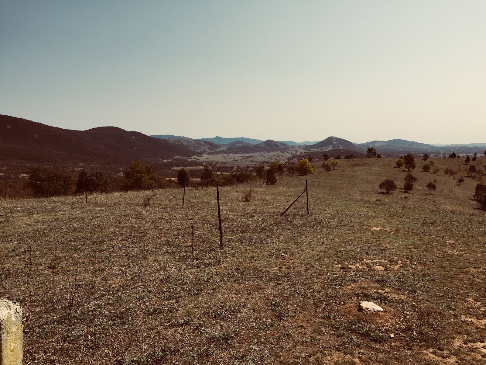
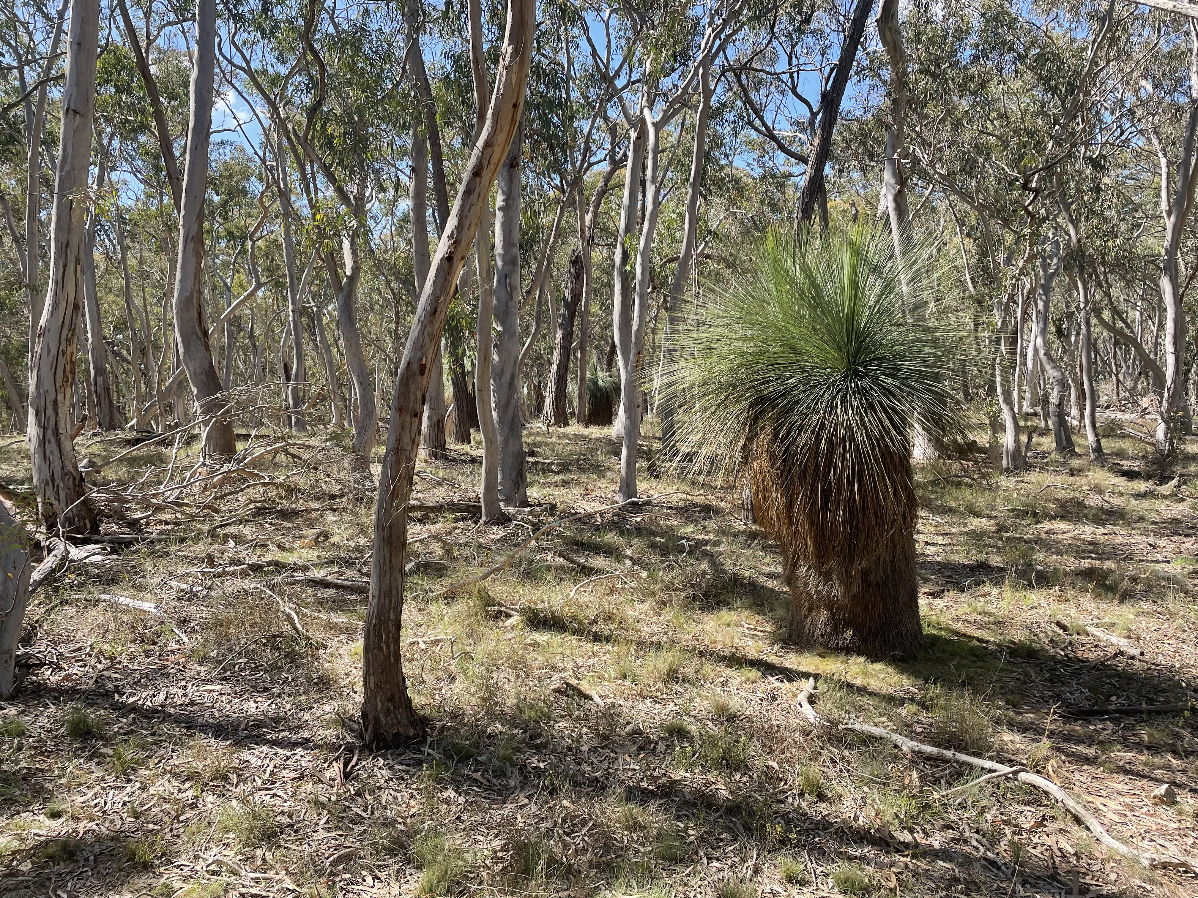
While technically this walk was bush bashing, it was extremely easy walking through light forest and short grass. Although the Reserve is relatively small (441 hectares) it can easily provide three or four hours of excellent walking. There are no clear views from the highest peaks, but there are views all along those parts of the border fenceline that we walked along.

Saturday, 23 March 2024

Tarlo River National Park: Exploration of Areas South and North of Towrang Road

General Information


Grading:  medium
Distance:   8.9 kilometers
Total climb:   343 meters
Time taken:   3 hours 45 minutes
Map:  Chatsbury 8828-1N 1:25 000
Start point distance by road from Canberra GPO:   123 kilometers
Start point map grid reference:  55H GB 69327 69324
Destination map grid reference:  no specific destination
End point:  same as start

Route


Description

The Tarlo River National Park is difficult to access, with only one public road (Towrang Road) passing through a small part of the Park's south eastern extremity. A good starting point for walking in Tarlo River National Park north or south of Towrang Road is where it meets the Quarry Trail, only a few hundred metres inside the Park. This is where we started.

We decided to explore the area south of Towrang Road first, and made our way along Towrang Road for about 350 metres before heading into the bush. It wasn't long before we came across the first of the Permian conglomerate outcrops which are a feature of this area.

These can be found around the numerous steep, but easily accessible gullies that pervade the area. The bottoms of most gullies are covered in thick ferns, and care needs to be taken when walking through it as it obscures fallen trees and other hazards.

We headed generally south, going down into one gully and back again up the ridge before the next gully. The ridges were dry forest and the walking around them was very easy.

Reaching as far south as we wanted to go, and wanting to leave some time to explore north of the road, we turned around and navigated to the Yururga Trail which we followed back to Towrang Road and our starting point. Stopping for lunch here, we then went into the northern section and had a bit of a look around. It was also a series of ridges and gullies, but less interesting than the southern section.

After exploring for only a relatively short distance we decided to return to our starting point, although by a different route.

It might be useful in the future to spend a day walking north of Towrang Road to see how far we could get into the main area of the Park. 

Thursday, 2 November 2023

Brindabella National Park: Devils Peak

General Information

 
Grading:  medium
Distance:   4.9 kilometers
Total climb:   268 meters
Time taken:   3 hours 30 minutes
Maps:   Cotter Dam 8627-2N 1:25 000
Start point distance by road from Canberra GPO:   48 kilometers
Start point map grid reference:  55H FA 66441 95586
Destination map grid reference:   55H FA 66448 94353
End point:  Same as start

Route


Description

This walk started at a point on Two Sticks Road under some power lines about 1.5 kilometers from the intersection of Two Sticks Road and Blue Range Road. We headed straight into the bush, which was quite thick and difficult to walk through, with virtually no hope of being able to walk in a straight line.


As we were walking the terrain kept turning us to the right, so we decided to make for the lesser peak to the north west of Devils Peak. This was not a bad decision since it gave us some good views to the north and west.

We then turned south east towards Devils Peak. We arrived at the actual peak itself, but it was thickly forested and gave no decent views. We continued south east, however, until we came to the rock face looking east, and there were great views towards Mount Blundell and Mount Coree.


We returned to our starting point pretty much the same way (but obviously not going back up the lesser peak we had climbed earlier).

Thursday, 1 October 2020

Yass District: Mundoonen Nature Reserve North of the Hume Highway

General Information

Grading:  medium
Distance:   10.5 kilometers
Total climb:   470 meters
Time taken:   3 hours 40 minutes
Maps:   Jerrawa 8728-3N 1:25 000
Start point distance by road from Canberra GPO:   65 kilometers
Start point map grid reference:  Jerrawa 55H FB 872782 44043
Destination map grid reference:  Jerrawa 55H FB 87286 47036
End point:  Same as start

Route

Description

The Mundoonen Nature Reserve straddles the Hume Highway between Yass and Gunning. We decided to do the smaller section of the Reserve north of the Hume Highway. Our starting point was the Sheldricks Lane turnoff, about 3.4 kilometres along the Hume Highway from its intersection with Yass Valley Way.

Our first task was to climb up the access road to the summit of Mt Mundoonen. Unfortunately there are only limited views here due to the surrounding forest, but it's another peak to take off my list.

Passing the trig marker we continued to the end of the paved road near the towers in the distance. At the point we turned left to follow the ridge heading a bit east of north. The top of the ridge is easy walking through dry sclerophyll forest.

We followed the ridge until we came to a knoll at map reference 55H FB 87231 45102. Ahead of us was a deep gully with another hill on the other side, so we started to walk down the ridge on the left before heading north again at a lower elevation. We found a couple of mostly dry watercourses which were quite nice to walk along while they took us in roughly the right direction.

At map reference 55H FB 87008 46349 we found the abandoned farmhouse complex which we had heard about, all still in very good condition. We paused there for lunch.

From the farmhouse we made our way to the dam at map reference 55H FB 87196 46802...


...and from there continued north to the boundary fence of the Nature Reserve. We followed the boundary fence to the east, which took us to the hill at the end of the ridge we followed from Mt. Mundoonen.

There were some nice rural views to the north from there

We followed the ridge all the way back to Mt. Mundoonen and our starting point, including this time the steep hill we avoided on the outward journey.

Thursday, 24 September 2020

Canberra Nature Park: Gungaderra Grasslands Nature Reserve

General Information

Grading:  easy
Distance:   4 kilometers
Total climb:   128 meters
Time taken:   1 hours 15 minutes
Maps:   Canberra 8727-2N 1:25 000
Start point distance by road from Canberra GPO:   8 kilometers
Start point map grid reference:  Canberra 55H FB 92425 01103
Destination map grid reference:   n/a
End point:  Same as start

Route

Description

This walk commenced just off the Barton Highway outside the entrance to the 1RPH radio station. We had to climb a barbed wire fence near a locked gate to get into the reserve (we found a few other wire fences during the walk but we were able to find gaps in them).

Proceeding up the track inside the gate our first order of business was to find some ancient gnarly trees that we had heard about. This required some backtracking, but we eventually found the trees one after another in the light forest to the left of the track.

After finding the trees we walked up to the top of Gungahlin Hill (map ref. 55H FB 92348 01747) before heading northeast to another hill at the northern end of the grasslands (map ref. 55H FB 92173 02334). There were some nice views across the grasslands from here.

Turning back we headed for a third hill in the grasslands (map ref. 55H FB 92933 01600), also with some nice views.

 From here it was a short walk back through grassland and light forest back to our starting point.

Friday, 22 March 2019

Namadgi National Park: Ginini Creek Waterfalls North of Ginini Flats

General Information

Grading:  medium
Distance:   3.3 kilometers
Total climb:   128 meters
Time taken:   1 hour 45 minutes
Maps:   Corin Dam 8626-1N 1:25 000
Start point distance by road from Canberra GPO:   75 kilometers
Start point map grid reference:  Corin Dam 55H FA 61314 67102
Destination map grid reference:   Corin Dam 55H FA 61503 69130
End point:  Same as start

Route

http://maps.six.nsw.gov.au/

Description

This walk began at the locked gate on Mt Franklin Road at the base of Mt Ginini. We headed through the bush immediately to the north of the carpark, passing through gum trees and moderately dense waist-high scrub until we could see Ginini Flats below us.

Continuing on we came to the edge of the Ginini Flats swamp, which was a bit of a mistake as the scrub became considerably denser near the swamp, and the swamp itself naturally posed its own walking problems. Still, it was very nice to look at close up.

We headed back into the bush, climbing up to where the scrub was less dense. Eventually we saw the steep gully that Ginini Creek passes through, giving a nice view through the gap back towards Mt Franklin and Canberra in the far distance.

Descending steadily (and in places steeply) we made our way down to the top of the series of waterfalls on Ginini Creek.

While it would have been relatively easy to keep going down to where the more substantial falls are (these are visible from the Mt Franklin Summit), we noticed at this stage that some dark clouds were heading our way and there was a sound of distant thunder. Reluctantly we decided to head back in the interests of comfort and safety. We headed back along the ridge to the west of Ginini Flats, which was pretty easy bush to get through and is probably the best route down to the falls and back. We made it back to the car with minutes to spare before heavy rain set in.

Wednesday, 5 September 2018

Gigerline Nature Reserve: An Exploratory Wander

General Information


Distance:   9.4 kilometers
Total climb:   384 meters
Time taken:   3 hours  30 minutes
Maps:   Williamsdale 8726-4N 1:25 000
Guide:  n/a
Start point distance by road from Canberra GPO:   36 kilometers
Start point map grid reference:  55H FA 88439 66291
Destination map grid reference:  55H FA 89277 64520
End point:  same as start

Route


http://maps.six.nsw.gov.au/

Description


This was an exploratory hike in an area my fellow hiker and I had not been before. We did not have a particular route or destination in mind, so the destination point specified above is really just the most prominent feature we came to.

Starting from the Tharwa Sandwash carpark we followed the Murrumbidgee River upstream for about 700 meters before crossing a dry creek at map reference 55H FA 89118 65976. From there we started up a ridge paralleling the river, which gave us a nice aspect downriver towards Tharwa in one direction and to the distant Tinderry Range in the other.


Not far up this ridge we came to the first of many annoying barbed wire fences that still criss-cross the Nature Reserve. Having wormed our way under a gap in this particular fence we continued in a generally southern direction and gaining elevation as we went. Eventually we saw the unnamed hilltop at map reference 55H FA 89277 64520, and decided to make towards it, believing that it would help us orient ourselves and look for more places of interest. This proved to be an excellent decision, with the hilltop affording views all around.


From the hilltop we decided to head back towards the Murrumbidgee heading down the hill to link up with a track we could see below us to the east. We followed this track around, hoping to find a side-track off to the left that would take us to the river (as marked on the map retrieved from http://maps.six.nsw.gov.au/). We never did find this side-track, so it must have been obscured over time. This left us with the job of descending a steep slope through relatively thick scrub to get to the river, but we made it quite easily in the end and found a very nice spot for lunch.


After lunch we climbed out way back from the river and soon after reacquired our outbound trail which we followed back to the carpark.

Monday, 7 December 2015

Tidbinbilla Nature Reserve: Billy Billy Rocks - North/South Route

General Information


Distance:  5.4 kilometers
Total climb:  347 meters
Time taken:  7 hours
Map:  Corin Dam 8626-1N; 1:25: 000
Guide:  Graeme Barrow, Namadgi & Tidbinbilla Classics: Tough Bushwalks in Canberra's 
                                        High Country (2000), pp. 25-27.
Start point distance by road from Canberra GPO:  52 kilometers
Start point map grid reference: 55H FA 73102 67537
Destination map grid reference:  55H FA 71942 69153
End point:  same as start


Route


http://maps.six.nsw.gov.au/

Description


Billy Billy Rocks is a rocky peak in the south of the Tidbinbilla Nature Reserve. There are two main routes off Corin Road to get to the Rocks, one approaching from the east and the other from the south. On this occasion we decided to do the north-south route. This starts at Square Rock carpark, which is just a bit after the Corin Forest recreation area. Crossing Corin Road from the carpark we initially headed north and then west, avoiding the boggy ground around Gibraltar Creek. The climb was only moderate in the early stages of the hike, but it became steeper as we veered northwest up the hill at map reference FA721686 where there is a Bogong cave. As well as the steepness of the climb, we were faced with thick scrub and lots of fallen trees, a legacy of the 2003 bushfires. Due to these factors, it took us over 2 hours to hike our first 2 kilometers. Arriving at the peak at FA721686 we searched for the Bogong cave but without success. There were some interesting rock formations here though.


We then hiked due north towards Billy Billy Rocks. This meant we had to descend through the continuing dense scrub and fallen trees down to Billy Billy Creek and then climb up the other side. This took us another hour or so. Perhaps we would have been better off following the contours around to the west and then veering east to approach the Rocks. We spent some time exploring the Rocks, but were unable to find the stone cairns that would lead us to the best views over Namadgi and Tidbinbilla. We did get a few glimpses through the rocks and trees though.


Running short on time we decided to head back - not a pleasant thought given the terrain we had walked through to get to the Rocks. For some crazy reason we walked back to the peak at FA721686, which we should have just walked around to the east, saving us another climb. We then headed roughly straight southeast to get back to the car. This took us through the boggy ground around Gibraltar Creek, where I managed to stand on a red-bellied black snake which thankfully slithered off away from me.

Graeme Barrow rated this walk as "Hard" back in 2000, but given the post-bushfire regrowth and fallen trees it has become even more difficult. Barrow said that the walk should take 4.5 hours, but we took 7 wearying hours. My co-hikers and I decided that next time we would use the west-east route, where we had heard that there is at least a track of some description.