Tuesday 26 March 2019

Cuumbeun Nature Reserve: Faunce Hill

General Information

Grading:  medium
Distance:   12.5 kilometers
Total climb:   503 meters
Time taken:   3 hours 45 minutes
Maps:   Bungendore 8726-2N 1:25 000; Hoskinstown 8727-2S  1:25 000
Start point distance by road from Canberra GPO:   20 kilometers
Start point map grid reference:  Bungendore 55H GA 06436 85040
Destination map grid reference:   Hoskinstown 55H GA 06027 81781
End point:  Same as start

Route

http://maps.six.nsw.gov.au/

Description

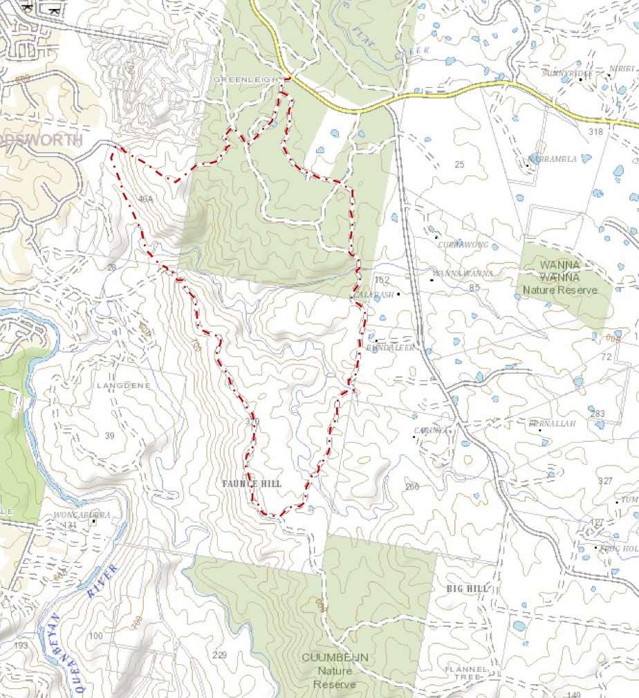
This walk began at the Link Road entrance to Cuumbeun Nature Reserve, just off the Captains Flat Road. 

Walking along the Link Trail for a short distance we turned off onto the Swamp Trail and followed it south to the Queanbeyan River Trail, which we in turn followed until we met another unnamed trail heading north towards Faunce Hill. The views from the Hill were restricted by surrounding trees.

The views opened up a bit, however, as we headed back north from Faunce Hill.

The track north was pretty rough, with one particularly steep and treacherous section just before we left it.

Leaving the track at map reference 55H GA 05398 83520 we followed a walking track which took us through light bush and past a rather nice gully where we stopped for lunch.

We continued along the walking trail until it ended at the Ellerton Drive Extension roadworks. We then started climbing to the water tanks at 55H GA 05096 84488 and then up the nearby peak (55H GA 05472 84207) where we found another walking trail heading back east towards our car via the Queanbeyan River Trail and the Link Trail.

Friday 22 March 2019

Namadgi National Park: Ginini Creek Waterfalls North of Ginini Flats

General Information

Grading:  medium
Distance:   3.3 kilometers
Total climb:   128 meters
Time taken:   1 hour 45 minutes
Maps:   Corin Dam 8626-1N 1:25 000
Start point distance by road from Canberra GPO:   75 kilometers
Start point map grid reference:  Corin Dam 55H FA 61314 67102
Destination map grid reference:   Corin Dam 55H FA 61503 69130
End point:  Same as start

Route

http://maps.six.nsw.gov.au/

Description

This walk began at the locked gate on Mt Franklin Road at the base of Mt Ginini. We headed through the bush immediately to the north of the carpark, passing through gum trees and moderately dense waist-high scrub until we could see Ginini Flats below us.

Continuing on we came to the edge of the Ginini Flats swamp, which was a bit of a mistake as the scrub became considerably denser near the swamp, and the swamp itself naturally posed its own walking problems. Still, it was very nice to look at close up.

We headed back into the bush, climbing up to where the scrub was less dense. Eventually we saw the steep gully that Ginini Creek passes through, giving a nice view through the gap back towards Mt Franklin and Canberra in the far distance.

Descending steadily (and in places steeply) we made our way down to the top of the series of waterfalls on Ginini Creek.

While it would have been relatively easy to keep going down to where the more substantial falls are (these are visible from the Mt Franklin Summit), we noticed at this stage that some dark clouds were heading our way and there was a sound of distant thunder. Reluctantly we decided to head back in the interests of comfort and safety. We headed back along the ridge to the west of Ginini Flats, which was pretty easy bush to get through and is probably the best route down to the falls and back. We made it back to the car with minutes to spare before heavy rain set in.

Tuesday 12 March 2019

Canberra Nature Park: Aranda Bushland and Black Mountain

General Information

Grading: easy
Distance:   11 kilometers
Total climb:   390 meters
Time taken:   2 hours 35 minutes
Maps:   Canberra 8727-2N 1:25 000
Start point distance by road from Canberra GPO:   6.4 kilometers
Start point map grid reference:  Canberra 55H FA 89102 96546
Destination map grid reference:   Canberra 55H FA 90789 94434
End point:  Same as start

Route


http://maps.six.nsw.gov.au/

Description

This walk began at the Aranda Shopping Centre in Bandjalong Crescent and, similar to the walk undertaken on 26 February 2019, followed a route through the suburb of Aranda and the Aranda Bushland until just short of Bindubi Street. From there we looped around through more of the Aranda Bushland to the Caswell Drive underpass. On the eastern side of Caswell Drive we proceeded south along the Swampy and Woodland Trails until we reached the Lakeview Trail, where we began a steep and somewhat treacherous climb towards Black Mountain Drive.

Reaching Black Mountain Drive we crossed over the road and slightly uphill from there we picked up a walking track to the old Black Mountain picnic area where we paused to take in the view.

We continued along a faint walking trail to the summit of the mountain, and then down the northern side, initially via a walking trail and then the Link Trail before turning west back towards Aranda. This time we crossed Caswell Drive via the overpass into Noala Street, Wangara Street and Bandjalong Crescent, back to the Aranda Shops.


Friday 8 March 2019

Canberra Nature Park: Mount Ainslie Quarries

General Information

Grading:  easy
Distance:   5.5 kilometers
Total climb:   268 meters
Time taken:   2 hours
Maps:   Canberra 8727-2N 1:25 000
Start point distance by road from Canberra GPO:   2.3 kilometers
Start point map grid reference:  Canberra 55H FA 95455 94871
Destination map grid reference:   Canberra 55H FA 96504 94712
End point:  Same as start

Route


http://maps.six.nsw.gov.au/

Description

This walk began at the intersection of Chisholm and Duffy Streets in Ainslie. Initially we went through the bush following a rough path until it ended at a management trail which we followed to the left. Coming to the creek bed shown on the map we again went bush following the dry watercourse to the lookout just below the summit of Mt Ainslie looking south.

Taking the tourist path up to the road around the summit we walked around to the right until we found the path to the first of Mt Ainslie's quarries. Coming from the top of the mountain care is needed when approaching the quarry as there's a bit of a cliff drop to be avoided.

We walked around the top of the quarry to the left...

...quickly reaching the bottom.

To the southwestern side of the quarry is a path which we followed around the mountain before descending to another management trail which we followed until we came across the second quarry site on Mt Ainslie.

From there we went down towards the back of the War Memorial and the old CSIRO building back to where we started the walk.