Sunday 21 December 2014

Namadgi National Park: Bendora Arboretum

General Information


Distance:  3 kilometers
Total climb:  100 meters
Time taken:  1 hour 30 minutes
Map:  Tidbinbilla 8627-2S, 1:25 000
Guide:  Marion Stuart, Best Bush, Town and Village Walks in and around the ACT (2012); 
                                    pp. 64-67.
Start point distance by road from Canberra GPO:  59 kilometers
Start point map grid reference:  55H FA 62374 79504
Destination map grid reference:  55H FA 63159 78537
End point:  same as start


Route


http://maps.six.nsw.gov.au/

Description


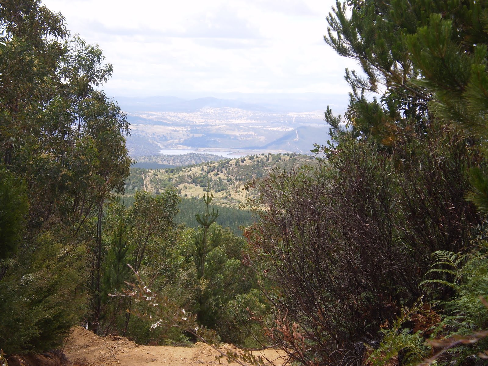
This is a very short walk that starts at a locked gate at the start of Chalet Road, just off Mount Franklin Road. Going through the gate we followed Chalet Road to the south and then east until we came to Bendora Hut.


We then entered the arboretum and wandered among the stands of different types of trees (mostly conifers) planted between 1940 and 1958. There is a methodical self-guided walk that can be followed, but we decided to just randomly walk through whatever looked most interesting.


We returned to the locked gate by the same path. Given the distance that needs to be driven too get there, this walk would best be combined with some other activity requiring travel along Mount Franklin Road. Having said that, the short walk is well worth the effort; it is, after all, the only arboretum to survive the 2003 bushfires.

Wednesday 26 November 2014

Uriarra Pine Forest: Blue Range Hut

General Information


Distance:  7 kilometers
Total climb:  unknown
Time taken:  2 hours 30 minutes
Map:  Cotter Dam 8627-2N, 1:25 000
Guide:  Marion Stuart, Best Bush, Town and Village Walks in and around the ACT (2012); 
                                    pp. 68-71.
Start point distance by road from Canberra GPO:  40 kilometers
Start point map grid reference:  55H FA 70503 93001
Destination map grid reference:  55H FA 70582 93234
End point:  same as start


Route


http://maps.six.nsw.gov.au/

Description


The starting point for this hike is a locked gate on Blue Range Road just north of its crossing of Blue Range Creek. We started walking past the gate along blue range road for about 250 meters until we reached Blue Range Hut. Having just started walking, however, we just passed it by and continued to follow Blue Range Road through some rather nice native forest to the north and then the west before entering the pine forest.


There are occasional views of the pine forest, Cotter Dam and distant Canberra as you gain elevation.


About 1.4 kilometres into the walk Blue Range Road turns south and we followed it for about 2 kilometers before reaching an intersection (map grid reference 55H FA 69576 92431) where we turned left (northeast). This took us back to Blue Range Road about 500 meters south of our starting point. We then walked north back to Blue Range Hut where we could have some lunch and enjoy the native forest before heading home.

This is an interesting walk that isn't too taxing. The views are pleasant without being spectacular and the track is wide and easy to follow. Take time to read about the history of Blue Range Hut while you are there.

Thursday 20 November 2014

Namadgi National Park: The Settlers Track

General Information


Distance:  9 kilometers
Total climb:  unknown
Time taken:  about 4 hours
Maps:  Shannons Flat 8626-2S, 1:25 000; Yaouk 8626-2N, 1:25 000
Guide:  link
Start point distance by road from Canberra GPO:  81 kilometers
Start point map grid reference:  55H FA 79265 28028
Destination map grid reference:  Brayshaws Hut - 55H FA 79189 28126
                                                    Waterhole Hut - 55H FA 76231 29099
                                                    Westermans Homestead - 55H FA 77948 26775
End point:  same as start


Route


http://maps.six.nsw.gov.au/

Description


This walk starts from a parking area on Boboyan Road a bit over 2 kilometers north of the NSW/ACT border. Brayshaws Hut, the first of three restored settler huts to be visited on the walk, is nearby.


From Brayshaws we followed a clear trail west through grassy country with occasional remnants of settler structures.


Eventually the trail led us to Waterhole Hut, about 3.7 kilometre from our starting point, and its very scenic surrounds .


We then joined the Waterholes Fire Trail and followed it south and the southeast for about 4.3 kilometers to Westermans Homestead.


From Westermans we took the walking track heading northeast back to the carpark about two kilometers away.

This is a very nice walk which only suffers from the fact that it took me almost an hour and a half to drive from my house to the starting point. Still it is well worth the effort, if only for the history of the areas' settlers. It's a good idea to take the Settlers Track brochure with you (link) as it provides a lot of the historical context for the walk.

Tuesday 4 November 2014

Tidbinbilla Nature Reserve: Gibraltar Peak (1)

General Information


Distance: 7 kilometers
Total climb: 354 meters
Time taken: 2 hours
Map: Tidbinbilla 8627-2S 1:25 000
Guide:  link
Start point distance by road from Canberra GPO:  45 kilometers
Start point map grid reference:  55H FA 74987 75469
Destination map grid reference:  55H FA 76766 74314
End Point:  Same as start


See blog for later identical walk on 8 June 2015.

Tuesday 28 October 2014

Canberra Nature Park: One Tree Hill (1)

General Information


Distance: 7.2 kilometers return
Total climb: 232 meters
Time taken: 1 hour 50 minutes
Map:  Hall 8727-4S, 1:25 000
Guide:  ACT Centenary Trail - link
Start point distance by road from Canberra GPO:  15 kilometers
Start point map grid reference:  55H FB 88578 06552
Destination map grid reference:  55H FB 90528 09191
End point:  same as start


See blog for later identical walk on 23 July 2016.

Tuesday 21 October 2014

Tidbinbilla Nature Reserve: Devils Gap

General Information


Distance:  4 kilometers
Total climb:  190 meters
Time taken:  about 1 hour
Map:  Tidbinbilla 8627-2S, 1:25 000
Guide:  link
Start point distance by road from Canberra GPO:  46 kilometers
Start point map grid reference:  55H FA 79265 73679
Destination map grid reference:  55H FA 75293 72706
End point:  same as start


Route


http://maps.six.nsw.gov.au/

Description


This walk starts at the Devils Gap carpark on the eastern side of the Tidbinbilla ring road. From the carpark I followed the Devils Gap fire trail in a short but steep climb up to Devils Gap. There were some views along the way, although most of the walk was through fairly thick forest.


From Devils Gap it is possible to go on for about 1 kilometer to reach Corin Road near Woods Reserve. As I had tacked this walk onto an already full day of walking, however, I decided to stop at Devils Gap and return the same way. While this isn't a particularly scenic walk, the climb up the range gets the heart pumping. It's a good short walk for the sake of having a walk through the forest.

Tidbinbilla Nature Reserve: Hanging Rock, Ashbrook Fire Trail, Koala Enclosure, Peppermint Trail and The Sanctuary

General Information


Distance:  8.5 kilometers
Total climb:  about 110 meters
Time taken:  about 2 hours
Map:  Tidbinbilla 8627-2S, 1:25 000
Guide:  link
Start point distance by road from Canberra GPO:  49 kilometers
Start point map grid reference:  55H FA 72373 72783
Destination map grid reference:  loop walk
End point:  same as start


Route


http://maps.six.nsw.gov.au/

Description


This walk is a combination of several walking trails in the Tidbinbilla nature Reserve. I started at the Hanging Rock carpark and headed first along Ashbrook Creek towards Hanging Rock, a group of granite tors once used for shelter by local Aboriginal people.


Retracing my steps back to the carpark, I then walked up the Ashbrook fire trail. This follows the very pretty Ashbrook Creek west for a bit over one kilometer before turning north.


The fire trail runs through thick forest and eventually meets Mountain Creek, which I was able to cross without getting my feet wet thanks to some well-placed rocks.


Form Mountain Creek there is a final climb to the end of the Ashbrook fire trail at Mountain Creek Road. I turned right down Mountain Creek Road, all the time scanning the trees to my right for koalas in the koala enclosure. No luck this time. Reaching the Tidbinbilla ring road, I went into the koala enclosure and walked the 1.8 kilometer Peppermint Trail loop before entering the northern end of the Sanctuary.


Walking through the Sanctuary I eventually came to the main Sanctuary entrance and back onto the ring road which I followed to the left back to my car. This is a nice series of walks that allow you to see many of the attractions of this part of the Nature Reserve.

Saturday 11 October 2014

Canberra Nature Park: Shepherds Lookout, Molonglo River Plank Bridge and Uriarra Loop (1)

General Information


Distance:  9.3 kilometers
Total climb:  275 meters
Time taken:  3 hours 15 minutes
Map:  Umburra 8727-1S 1:25 000
Guide:  Marion Stuart, Best Bush, Town and Village Walks in and around the ACT (2012), 
                                     pp.80-83 & 76-79.
Start point distance by road from Canberra GPO:  19 kilometers
Start point map grid reference:  55H FA 809211 97979
Destination map grid reference:  Shepherds Lookout - 55H FA 79899 98441
                                                    Molonglo River plank bridge - 55H FA 78470 98044
                                                    Uriarra Crossing - 55H FA 77646 98169
End Point:  Same as start


I did this walk again on 9 August 2015. Refer to blog for this later walk.

Thursday 9 October 2014

Canberra Nature Park: Mulligans Flat North

General Information


Distance:  4.7 kilometers
Total climb:  120 meters
Time taken:  about 1 hour
Map:  Hall 8727-4S 1:25 000
Guide:  Marion Stuart, Best Bush, Town and Village Walks in and around the ACT (2012). 
                                     pp. 98-101.
Start point distance by road from Canberra GPO:  17 kilometers
Start point map grid reference:  55H FB 96460 07752
Destination map grid reference:  loop walk
End point:  same as start


Route


http://maps.six.nsw.gov.au/

Description


This walk starts at the carpark on the northern side of Mulligans Flat Road about 2.3 kilometers northeast of Horse Park Drive. Although the walk starts right on the edge of suburbia, it takes you through some very nice rural and forest landscapes along a well- marked trail. I chose to do the walk in a clockwise direction, which means that the first 1.4 kilometers is a relentless 100 meter climb, almost to Oak Hill.


From there I turned east to follow the trail along the fence line that is the ACT/NSW border. There are some nice rural views from this section with the city of Canberra in the background to the south.


After a while the track (and the border fence) descends to the south back towards Mulligans Flat Road. There are some more nice spots here.


Staying within the Nature Reserve, the track parallels Mulligans Flat Road back to the carpark. A nice view here back towards Oak Hill.


This is a very enjoyable (and quite popular) walk which is easily accessible. The trail is easy to follow, and apart from the last bit of climb up towards Oak Hill, not all that strenuous.

Saturday 27 September 2014

Deua National Park: Big Hole (1)

General Information


Distance:  3.6 kilometers
Total climb:  120 meters
Time taken:  1 hour
Map:  Kain 8826-4S 1:25 000
Guide:  link
Start point distance by road from Canberra GPO:  129 kilometers
Start point map grid reference:  55H GA 39292 43340
Destination map grid reference:  55H GA 40570 42986
End point:  same as start


Route


http://maps.six.nsw.gov.au/

Description


The starting point for this hike was the Berlang camping area, off Cooma Road about 43 kilometers south of Braidwood. Soon after leaving the camping area I came to the Shoalhaven River. The water was shin-deep, so I took off my boots and waded across. This proved to be a bit painful, however, since the rocks I was walking over were quite sharp and painful on the soles of my feet.


After the river the walking trail gradually climbs through scrubby terrain with occasional views back to the valley.


At about 750 meters elevation the track curved around to the south taking me directly to Big Hole. This was actually far more impressive than I was expecting, and a viewing platform to one side of the Hole gives a pretty good view of the feature. I need a better camera though.


I returned to the carpark by the same route. This is a very good short walk, although it is in a fairly remote area. Walkers might want to consider having some form of footwear to make the river crossing a little less painful.

Friday 12 September 2014

Nowra: Ben's Walk and The Grotto North

General Information


Distance:  6 kilometers (about 3 kilometers each walk)
Total climb:  unknown
Time taken:  2 hours 30 minutes
Maps:  Nowra 9028-3S 1:25 000; Berry 9028-3N 1:25 000
Guide: none
Start point distance by road from Canberra GPO:  194 kilometers
Start point map grid reference:  Ben's Walk - 56H KG 79713 38368 [Nowra]
                                                   The Grotto North - 56H KG 79205 391205 [Berry]
Destination map grid reference:  loop walks
End point:  same as start


Note: These are actually two separate walks with a short drive between them. Ben's walk follows Nowra Creek on the south side of the Shoalhaven River at Nowra, while The Grotto North follows cliffs on the northern bank of the Shoalhaven at North Nowra.


Route


Ben's Walk


http://maps.six.nsw.gov.au/


The Grotto North

http://maps.six.nsw.gov.au/

Description


The start of Ben's Walk is on Scenic Drive just behind the Nowra Showgrounds. I followed the trail south above Nowra Creek past a suspension footbridge through a light forest with rocky outcrops.


Eventually the trail crossed the creek and started back north on the opposite bank through more bushland and a large grassy reserve back to the suspension footbridge.


Crossing the footbridge I then made my way to the point where Nowra Creek joins the Shoalhaven River. I then climbed up to Hanging Rock Lookout, which provided panoramic views over the Shoalhaven.


Returning from there to my car, I drove over to North Nowra to do The Grotto North walk starting at the western intersection of Yurunga Drive and Kareela Crescent. Following the trail I first had a great view of Nowra Creek and Hanging Rock Lookout from the other side of the Shoalhaven.


Descending towards the river I passed through some very nice forest with views of the escarpment above me.


After continuing along the river for a way I turned back and climbed back up the escarpment to my car. I could have continued further along the river and climbed back up the escarpment at Murrell Place, but after a long day of walking on my own I felt I had done enough.

These are both reasonably nice short walks if you happen to be in the Nowra area. Of the two I think that The Grotto North is the more interesting.

Abrahams Bosom Reserve: Coomies Walk

General Information


Distance:  8.2 kilometers
Total climb:  100 meters
Time taken:  2 hours 30 minutes
Map:  Currarong 9027-1N 1:25 000
Guide:  link
Start point distance by road from Canberra GPO:  218 kilometers
Start point map grid reference:  56H LG 01850 23575
Destination map grid reference:  loop walk
End point:  same as start


Route


http://maps.six.nsw.gov.au/

Description


I started this walk at the Abrahams Bosom Beach carpark at the end of Beecroft Parade in Currarong. After crossing Abrahams Bosom Creek and walking on a bit further I took the side track to see the wreck of the SS Merimbula which ran aground there in 1928. Retracing my steps for a short distance I followed the walking trail past Abrahams Head and Honeysuckle Point, which had occasional ocean views, before returning to the main track.


From there I followed the main track east until at map grid reference 56H LG 03088 23839 I followed the sigs towards Gosangs Tunnel and Mermaids Inlet. Gosangs Tunnel leads to a rock shelf above the ocean cliffs, while Mermaids Inlet is a step and narrow inlet just north of Beecroft Head.


Retracing my steps to where I left the main track, I continued along Coomies Walk. Initially this was through light forest, but as I gained elevation the vegetation changed to shoulder-high scrub giving some more nice views towards the ocean. The views from Merimbula Trig (62 meters) were quite good.


From the trig the trail started to head back to the starting point, at first through scrub and then back through light forest. There is an Aboriginal rock shelter on the way back that is well worth a look.

A beautiful walk in a beautiful part of the world. The trail is easy to follow, although some parts were covered with water and needed to be walked around.