Showing posts with label Tallaganda. Show all posts

Friday, 16 August 2019

Tallaganda State Forest: Serenity Rocks and Mt Lowden

General Information

Grading: hard
Distance:   14 kilometers
Total climb:   750 meters
Time taken:   4 hours 45 minutes
Maps:   Bombay 8827-3S 1:25 000; Bendoura 8826-4N 1:25 000
Start point distance by road from Canberra GPO:   58 kilometers
Start point map grid reference:  55H GA 31672 67521
Destination map grid reference:   Serenity Rocks 55H GA 32965 69372
                                                     Mt Lowden Communications Tower 55H GA 33596 68115
End point:  Same as start

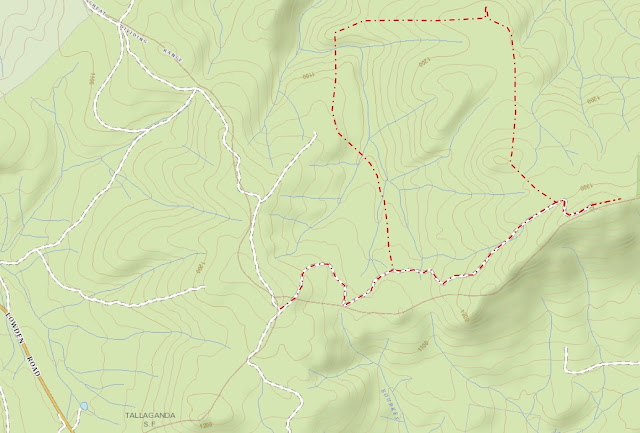
Route


http://maps.six.nsw.gov.au/

Description

This walk Started at the intersection of the Bald Hill and Lowden Trig Fire Trails, about 2.7 kilometers up the Lowden Hill Fire Trail from Lowden Road. We walked along Lowden Road looking for a foot track off to the left which we found at map reference 55H GA 32368 67765.

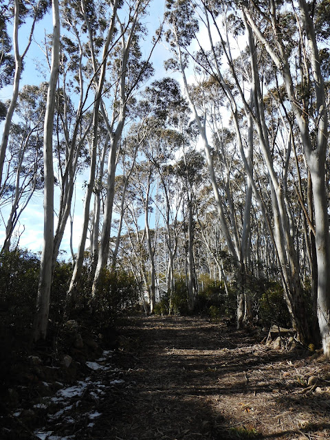
We followed this track through some very pretty forest down into gullies formed by tributaries of Mulloon Creek. The tributaries, which we had to cross several times, were lined with beautiful tree ferns.

The track finally started taking us back uphill and we continued right up to the side track of the Bald Hill Fire Trail at map reference 55H GA 31916 68585 before we decided that we were no longer going in the right direction. Backtracking down to the creek, we found a side trail heading north (map reference 55H GA 32037 68584) which we had failed to see on the way up because it was obscured by a fallen tree. This track, which seems to have mainly been used by trail bikes, took us all the way round to the informally named Serenity Rocks (map reference 55H GA 32965 69372). The rocks are about 100 meters off the track and look like this:


The rocks give an excellent platform for views north to Mt Palerang.


Going back to the walking/trail biking track, we started to head towards Mt Lowden. Pretty soon, however, we decided that the track was not taking us in the right direction, so we had to go bush and follow a bearing towards the Mt Lowden communications tower. While this was only a bit over a kilometre away, the dense scrub and occasional lawyer vines made it hard going. After about an hour-an-a-half of this slogging we finally made it back to the Lowden Hill Fire Trail, where at about 1300 meters there was still some of last week's snow in sheltered areas. From here it was only a short walk to the communications tower.


We continued past the communications tower thinking to reach the top of Mt Lowden about 600 metres distant. Again encountering thick scrub on the top of the ridge, however, we decided that it would take too much time and returned to the car via the Lowden Hill Fire Trail.
Tuesday, 7 May 2019

Tallaganda National Park: South Black Range Trig

General Information

Grading:  easy
Distance:   7 kilometers
Total climb:   250 meters
Time taken:   1 hour 45 minutes
Maps:   Bombay 8827-3S 1:25 000
Start point distance by road from Canberra GPO:   50 kilometers
Start point map grid reference:  55H GA 30854 74319
Destination map grid reference:   55H GA 29995 76996
End point:  Same as start

Route

http://maps.six.nsw.gov.au/

Description

This walk was a bit of an afterthought following a tour of the Molonglo Observatory Synthesis Telescope at Hoskinstown. This is well worth a look if you are lucky enough to find a tour operating.

To reach the starting point for this walk we drove to Hoskinstown and turned left on to Forbes Creek Road until its intersection with the North Black Range Fire Trail, not far past the National Park border. While there is a parking area at the intersection, we were a bit pressed for time and drove part way up North Black Range Fire Trail and parked there.

The native forest in this part of Tallaganda National Park is particularly striking.

We followed the fire trail north, a mostly gentle uphill climb. At one point we diverted off the trail into the bush, partly to better enjoy the forest and partly to take a shortcut to the South Black Range Trig (1262 metres). As with many shortcuts this proved a lot more difficult than it looked, and after my co-hiker took a nasty fall we decided to get back on to the fire trail. Around map reference 55H GA 30300 76900 there is a walking track off to the left which leads up to South Black Range Trig. We followed this track until we found the Trig on top of a huge boulder.

There were the remains of a wooden extension ladder near the boulder, half of which was quietly decaying on the ground and the remainder was propped up against the tree to the right of the picture above.

I suppose this must have been used by thrill seekers to shimmy across a tree branch to the top of the boulder, but neither of us thought it worth the risk. Sadly there is no clear view in any direction from South Black Range due to the forest all around.

We returned to our car by the same route, but this time avoiding false shortcuts through the bush. 

Wednesday, 24 October 2018

Tallaganda National Park: Mt Palerang

General Information


Distance:   3.2 kilometers
Total climb:   336 meters
Time taken:   2 hours 10 minutes
Maps:   Bombay 8827-3S 1:25 000
Start point distance by road from Canberra GPO:   60 kilometers
Start point map grid reference:  55H GA 35921 77365
Destination map grid reference:  55H GA 35938 76213
End point:  same as start

Route

http://maps.six.nsw.gov.au/


Description


This walk commenced at the intersection of the Mulloon, Gourock Range and Palerang fire trails in Tallaganda National Park, about 20 kilometers east of Hoskinstown. We had no particular walk in mind except that we wanted to climb Mt Palerang (1264m). We began by walking south along the Palerang Fire Trail, and after only 100 meters walking we came across an unexpected (and unmapped) walking track which seemed to be heading in the direction of Mt Palerang. Naturally we decided to follow this track which climbed quickly up one of Palerang's spurs. When we were nearing the 1200m elevation mark we noticed an indistinct track heading off in the direction of the summit, and after some discussion we decided to follow it rather than the more distinct track that we had been following. This took us up to the narrow ridge at the top of Palerang which we followed south through some moderately thick brush to the relatively impressive Palerang trig.


The views from the top of Palerang are limited by the surrounding bush, but in our case were even more limited by the weather conditions: mist and low cloud. Still, it was a great place to be, with no sound apart from birdsong and some beautiful bush surrounding it.


After lunching on the summit we headed back down, intending to take the spur to the southwest and eventually link up with the Palerang Fire Trail. As sometimes happens (at least to us) a rather cavalier attitude to navigation took us back to the walking track we had started on. Bowing to the inevitable, we decided to follow the track back down to the car.

Although the walk ended up being a lot shorter than we had planned, we decided not to do any more walking. Instead we decided to drive around the Tallaganda National Park and the Tallaganda State Conservation Area fire trials to scout out other walking opportunities. There seem to be plenty of options there, so it is likely that we will be back at some time soon.