General information
Distance: 28 kilometers
Total climb: 378 meters
Time taken: 6 hours 42 minutes (5 hours 30 minutes moving time)
Map: Endrick 8927-4S 1:25 000
Guide: none
Start point distance by road from Canberra GPO: 129 kilometers
Start point map grid reference: 56H KG 38115 06920
End point: same as start
Route

http://maps.six.nsw.gov.au/
Description
This was originally planned as a walk along the Redgrounds Track from the Morton National Park Endrick River entrance (near Nerriga) to where the Track crosses the Endrick River near Quiltys Pass. Since it was a beautiful day and we made the outward hike in better than expected time we went a bit further, following the Endrick River Trail west near Quiltys Pass before heading back the same way. We could have followed the Endrick River Trail all the way back to our car, which would have saved some distance, but this route leads through a large section of private land. It is possible to navigate through this area without trespassing (see link), but this route does not follow the formed roads and some serious navigation skills and equipment would be required.
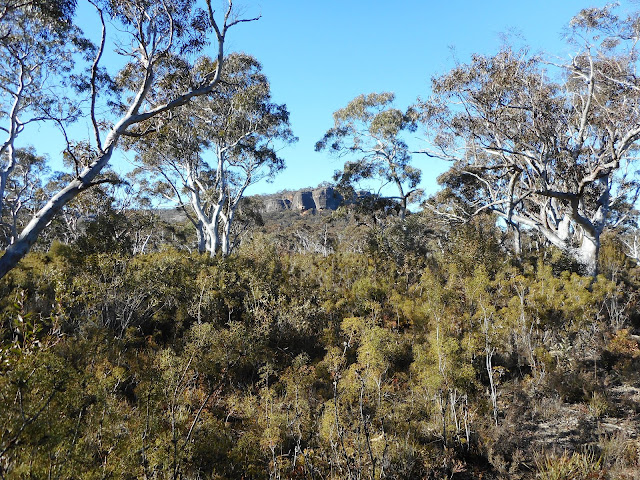
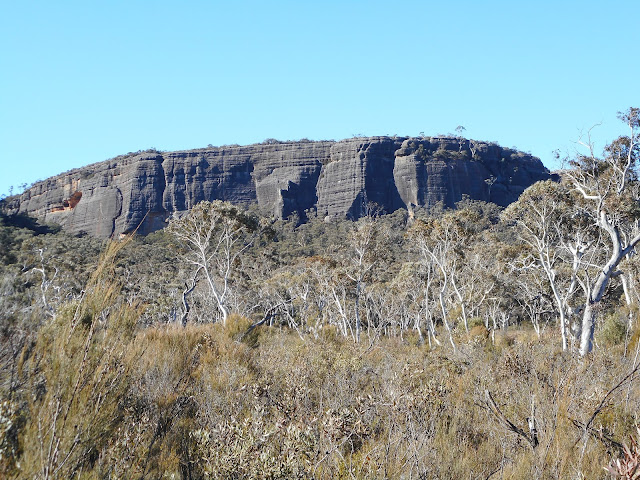
The first section of the walk was outside the National Park boundary along a hard and rocky track, all the time trying to keep to the formal route and avoid trespassing on private land. The route is not at all well signposted, however, so it is best to refer to the map. After about 1.8 kilometers we reached our first crossing of the Endrick River: an ankle deep ford which we were able to negotiate without getting too wet. From here the trail heads generally northeast climbing through medium-thick forest until a creek is reached at map reference 56H KG 42066 08324. The trail heads south and then southeast from here, eventually reaching flat and open country that starts to give some views of the surrounding escarpments.
We continued along the Track, crossing Piercy Creek with the forest becoming denser once more. As we approached Quiltys Clearing the Track became more difficult to follow, but with a bit of attention we navigated through without going off-trail. Soon after we arrived at the Endrick River once again, which we were able to easily cross thanks to some rock-hopping.

Having arrived here earlier than expected we had the choice of following the Endrick River Trail south towards The Vines or west towards Round Mountain. We chose the latter, with the idea of reaching a cave in Quiltys Mountain near Blacket Creek. As we followed the Track and saw the terrain, however, we got a better idea of how difficult it would be to reach the cave and agreed that there was probably insufficient time if we were to return to our car before sunset. We discussed whether we could cut back to the Redgrounds Track through the scrub to the north of us, but decided that this would probably take more time than retracing our steps, although we could have knocked about three kilometers off the return journey. The return along the Redgrounds Track allowed us to see everything from the reverse angle and take advantage of the afternoon sun on our views of the escarpments.


While it is long, this is a great one-day walk along a very good trail.
The first section of the walk was outside the National Park boundary along a hard and rocky track, all the time trying to keep to the formal route and avoid trespassing on private land. The route is not at all well signposted, however, so it is best to refer to the map. After about 1.8 kilometers we reached our first crossing of the Endrick River: an ankle deep ford which we were able to negotiate without getting too wet. From here the trail heads generally northeast climbing through medium-thick forest until a creek is reached at map reference 56H KG 42066 08324. The trail heads south and then southeast from here, eventually reaching flat and open country that starts to give some views of the surrounding escarpments.

We continued along the Track, crossing Piercy Creek with the forest becoming denser once more. As we approached Quiltys Clearing the Track became more difficult to follow, but with a bit of attention we navigated through without going off-trail. Soon after we arrived at the Endrick River once again, which we were able to easily cross thanks to some rock-hopping.

Having arrived here earlier than expected we had the choice of following the Endrick River Trail south towards The Vines or west towards Round Mountain. We chose the latter, with the idea of reaching a cave in Quiltys Mountain near Blacket Creek. As we followed the Track and saw the terrain, however, we got a better idea of how difficult it would be to reach the cave and agreed that there was probably insufficient time if we were to return to our car before sunset. We discussed whether we could cut back to the Redgrounds Track through the scrub to the north of us, but decided that this would probably take more time than retracing our steps, although we could have knocked about three kilometers off the return journey. The return along the Redgrounds Track allowed us to see everything from the reverse angle and take advantage of the afternoon sun on our views of the escarpments.


While it is long, this is a great one-day walk along a very good trail.


