Thursday, 16 April 2015

Mutawintji National Park: Homestead Gorge

General information


Distance: 8 kilometers
Total climb: unknown
Time taken: 3 hours
Map:  Nuchea 7335 1:100 000
Guide:  link
Start point distance by road from Canberra GPO:  1,096 kilometers
Start point map grid reference:  54J XL 23083 38129
Destination:  loop walk
End Point:  same as start


Route


http://maps.six.nsw.gov.au/


Description


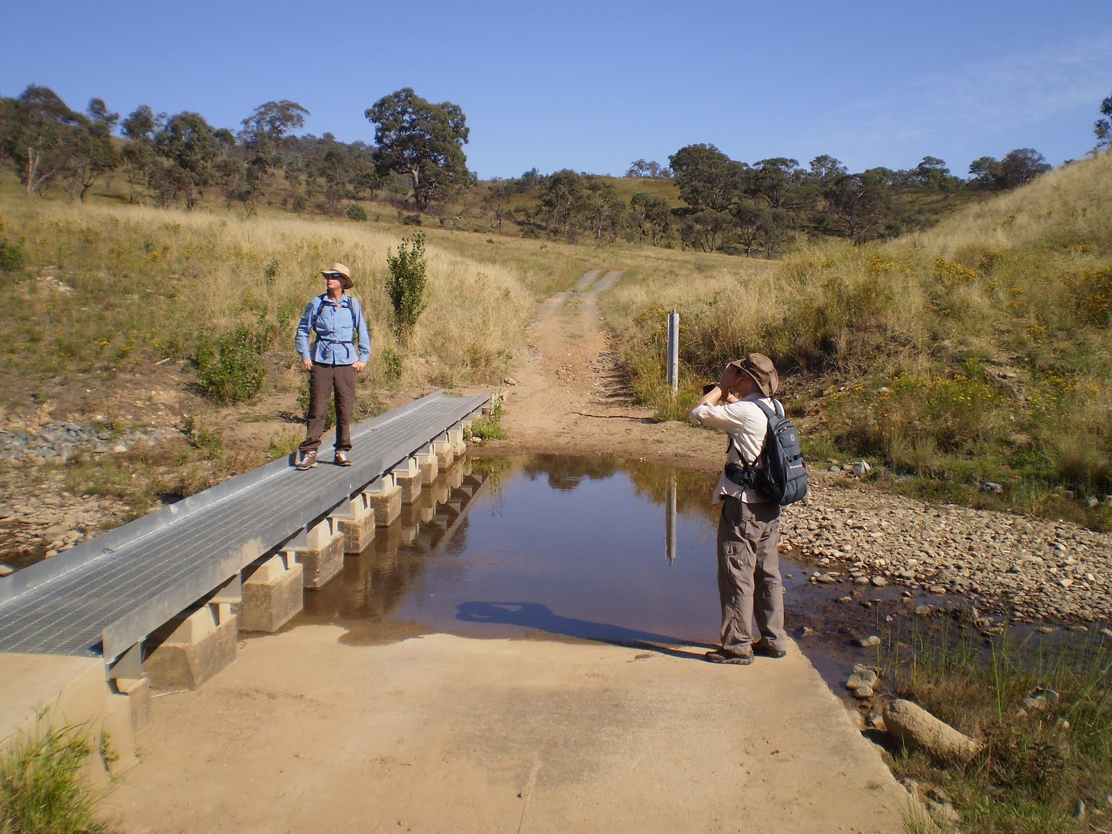
Mutawintji National Park is about 120 kilometers northeast of Broken Hill. We entered the Park via the Mutawintji Access Road, and about 5 kilometers into the Park we arrived at the (unmanned) visitors centre where we could get the latest information on the Park and take some refreshments after the long drive from Broken Hill. Normally we would have started walking from the picnic area about 2.7 kilometers further on from the visitors centre (map grid reference 54J XL 23933 38987), but due to an access road closure we were obliged to start at the campground about 1 kilometer from the visitor centre, making our walk a few kilometers longer. We followed markers from the campground, initially through open ground.


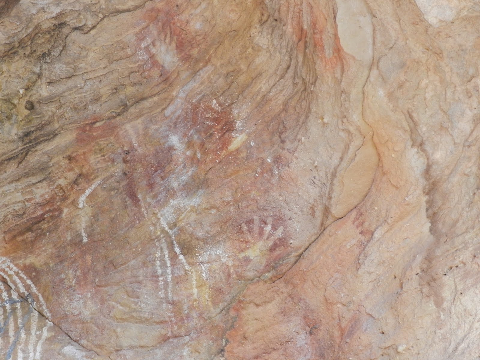
As we entered the Gorge there were occasional glimpses of the feral goats and some Aboriginal paintings under a rocky overhang (Thaaklatijka).


Following Homestead Creek the Gorge narrowed and became sandy underfoot.


About 2.8 kilometers into the walk we met the Rockholes Loop Walk, a short 1.9 kilometer diversion which required a bit of climbing but included some interesting features above the Gorge, including the rockholes themselves.


Returning to Homestead Creek we continued through the Gorge until we arrived at the rock pool at the end of the track.


Although we could have returned to the start point via the Byngnano Range Walk, one of our group was experiencing problems so we backtracked along the shorter way we had come.

This was an excellent walk through the sort of country I have not had the chance to experience before. The track is easy to follow, although the sandy surface in the Gorge and some climbing in the Rockholes Loop make life interesting. Most of the trail was dry, so take plenty of water. I would have liked to have continued along the Byngnano Range Walk, but it will have to wait for the next time.

Friday, 27 March 2015

Namadgi National Park: Mount Gingera and Brumbys Flats

General Information


Distance: 14.4 kilometers
Total climb: unknown
Time taken: about 4 hours
Maps:  Corin Dam 8626-1N 1:25 000
Guide:  none
Start point distance by road from Canberra GPO:  75 kilometers
Start point map grid reference:  55H FA 61322 48676
Destination map grid reference:  Mount Gingera - 55H FA 61271 61553
                                                    Brumbys Flats - 55H FA 60734 61877
End point:  same as start


Route


http://maps.six.nsw.gov.au/

Description


The starting point for the hike was the locked gate on Mount Franklin Road below Mount Ginini (which is as far as the public can drive south on Mount Franklin Road). We started the walk by continuing south along Mount Franklin Road roughly following the 1650 meter contour line on the eastern side of the Brindabella Range. After about 4 kilometers we passed Stockyard Spur track on the left and about 900 meters after that came to Pryors Hut, where we paused for our first break.


We then continued south along Mount Franklin Road a little over 1 kilometer from Pryors Hut where we came to the foot trail that leads to the summit of Mount Gingera (map grid reference 55H FA 61613 62088). This trail winds through fairly open country with occasional views of the surrounding ranges.


The track climbs 200 meters in just over 1 kilometer to the rocky summit of Mount Gingera (elevation 1855 meters), where more panoramic views can be found. Even in March there was still snow in rock cracks.


After another break at the summit we went off-trail, heading northwest to Brumbys Flats only 700 meters distant. This provided some more views to the south and west.


From Brumbys Flats we headed northeast, aiming for a gap (map grid reference 55H FA 60969 62135) between Mount Gingera and the unnamed peak of 1847 meters elevation northwest of it. We then started a steep descent down towards Pryors Hut through fairly dense forest, stopping in our tracks at one point when we came across a large number of feral pigs and having to wait until they moved on. Some more good views to the east from this descent, including in the later stages an elevated view of Pryors Hut.


Reaching Pryors Hut once again, we retraced our steps up Mount Franklin Road to our starting point.

Being mostly along Mount Franklin Road, this is a relatively easy walk through some very scenic country. As the second highest peak in the Australian Capital Territory (behind only Bimberi Peak at 1912 meters elevation), the views from the summit of Mount Gingera are extensive. The loop around to Brumbys Flats and down to Pryors Hut gives an opportunity for going off-trail and is very scenic in itself, with much of it still being above 1800 meters elevation.

Thursday, 26 February 2015

Hume and Hovell Walking Track: Mount Wee Jasper

General Information


Distance: 15.6 kilometers
Total climb: 700 meters elevation gain, total climb may be as much as 900 meters
Time taken: 5 hours
Map:  Couragago 8627-4S 1:25 000
Guide:  link
Start point distance by road from Canberra GPO:  88 kilometers
Start point map grid reference:  55H FB 52524 10232
Destination map grid reference:  55H FB 48996 07860
End point:  same as start


Route


http://maps.six.nsw.gov.au/

Description


This hike is along a part of the Hume and Hovell Walking Track, which runs from Yass to Albury-Wodonga, a distance of 440 kilometers. The starting point for our hike was the Fitzpatrick Trackhead, off Wee Jasper Road about 4 kilometers south of the town of Wee Jasper. From there we hiked up to the nearby caves for a look.


We then returned to the walking trail and heading roughly northwest parallel to Wee Jasper Creek. At map grid reference 55H FB 51286 10999 there is a stile to be crossed, at which point the track heads sharply south starting the main climb to the peak of Mount Wee Jasper. There are some nice views back over pine forests as you gain elevation.


At map grid reference 55H FB 50655 10377 (about 3 kilometers into the walk) we had to turn off the wide track we had been following on to a narrow walking trail.


Although the map shows the trail crossing several watercourses, when we went at the height of summer there was only one that had any obvious water in it (map grid reference 55H FB 49968 08439), and that was fairly unimpressive. We drank the water without any ill effects, though maybe we were just lucky.


Soon after we began the final ascent to Mount Wee Jasper.


The summit was fairly densely forested and there were clear views only towards Brindabella national Park to the east.


Having had lunch at the summit, we returned the way that we had come. Even though this was mostly downhill, the heat of late February along with the dearth of water made this return trip quite stressful. I suspect that it would be best to avoid this hike in the heat of summer. The extent of climbing required makes this a long and tiring walk. There is little water to be found along the way so it is necessary to carry at least 2-3 litres.

Saturday, 14 February 2015

Tidbinbilla Nature Reserve: Tidbinbilla Peak

General Information


Distance: 8 kilometers
Total climb: 670 meters
Time taken: I don't recall, but far too long
Maps:  Tidbinbilla 8627-2S 1:25 000
Guide:  None
Start point distance by road from Canberra GPO:  49 kilometers
Start point map grid reference:  55H FA 71471 74624
Destination map grid reference:  55H FA 70691 76926
End point:  same as start


Route


http://maps.six.nsw.gov.au/

Description


The starting point for the hike was Mountain Creek carpark. We started up the walking trail from the carpark and turned right where it met Tidbinbilla Range Road. We followed the road to a point at map reference 55H FA 71916 75748, about 2 kilometers into the walk, where there is a ridge heading up towards Tidbinbilla Peak. This is where the walk became difficult. We were almost immediately faced with a steep climb and a thick tangle of post-bushfire regrowth which we had to fight through almost to the summit.


Given the conditions, following the ridge to Tidbinbilla Peak was difficult but we eventually reached a flatter and more open area south of the peak. Some good views here.


We then had a last bit of a walk through waist-high scrub to the summit.


Some more great views from here, as you would expect.


After a break at the top we fought through all the scrub and regrowth to get back to Tidbinbilla Range Road and return to the start point. We were tired, scratched up and dirty from brushing up against burned tree trunks. Even though there is a sense of achievement and great views at the summit, I probably wouldn't recommend this walk. I suspect it will just get tougher as the regrowth gets thicker over time.

Saturday, 7 February 2015

Bungonia National Park: Red Track

General Information


Distance:  4.3 kilometers
Total climb:  400 meters
Time taken:  5 hours
Map:  Caoura 8928-3N; 1:25 000
Guide:  link
Start point distance by road from Canberra GPO:  124 kilometers
Start point map grid reference:  56H KG 27160 44914
Destination:  loop walk
End point:  same as start


Route


http://maps.six.nsw.gov.au/

Description


The starting point for this walk was the William Mitchell carpark. From there we followed the Red Track and got our first view of the Slot Canyon we would be walking through.


The descent to the western end of the canyon was very steep, but it didn't take too long to reach the bottom. At the western end of the canyon is a rather nice dry sandy area with high walls all around. This was a good place for a morning tea break.


Continuing eastwards along the canyon the sand gradually gave way to rocks which considerably slowed down our progress. We were required to go over, around or under a tangle of huge boulders.


Part way through the rocks Bungonia Creek also made an appearance, requiring us to trudge through the water at some points. Gradually the rocks became smaller and we could walk along Bungonia Creek without too many obstacles in our way. At map grid reference 56H KG 28007 45795 we reached the point where the Red Track combs back up out of the canyon. This is a very steep and difficult climb, with an ascent of 350 metres over a distance of 1 kilometer. Eventually we reached the point where the Red, Green and White Tracks meet, at which point we headed west back towards our starting point. This is a difficult but very rewarding walk.

Thursday, 1 January 2015

Googong Foreshores: London Bridge and Queanbeyan River

General Information


Distance:  8.6 kilometers
Total climb:  unknown
Time taken:  2 hours
Map:  Hoskinstown 8727-2S, 1:25 000
Guide:  link
Start point distance by road from Canberra GPO:  40 kilometers
Start point map grid reference:  55H GA 04782 67958
Destination map grid reference:  London Bridge Homestead - 55H GA 04628 66638
                                                    London Bridge Arch - 55H GA 05175 67464
                                                    Queanbeyan River - 55H GA 05410 69120
End point:  same as start


Route


http://maps.six.nsw.gov.au/

Description


The starting point for this walk is the London Bridge carpark at the end of London Bridge Road, about 3.4 kilometers from Burra Road. This is near the old London Bridge woolshed.


From the carpark we headed down the fire trail towards the heritage-listed London Bridge Homestead, crossing Burra Creek via a convenient footbridge.


The Homestead was an impressive group of old buildings, but sadly the main buildings had been fenced off so we could not get close to them. An apple tree overhanging the fence was full of fruit but they still had some ripening to do.


Having had a good look around the Homestead, we headed back up the fire trail to London Bridge Arch, where we explored underneath the arch and the surrounding shallow caves.


Moving from there along Burra Creek towards where it meets the Queanbeyan River we encountered thick tea tree which eventually forced us to climb up the hill to the fire trail heading north. We diverted off the fire trail to the hill at map grid reference 55H GA 05558 68365 to see what views we could get, but any decent view was mostly obscured by trees.


We continued north until we came to the point where Burra Creek meets the Queanbeyan River, which is quite a picturesque spot.


We started our return journey by following the Queanbeyan River to Washpen Crossing and then following the fire trail back to the London Bridge Arch walking trail. This time we walked over the Arch and continued back to the carpark. Apart from getting unnecessarily tangled in a tea tree thicket, this was a very enjoyable walk with plenty to see. 

Sunday, 21 December 2014

Namadgi National Park: Bendora Arboretum

General Information


Distance:  3 kilometers
Total climb:  100 meters
Time taken:  1 hour 30 minutes
Map:  Tidbinbilla 8627-2S, 1:25 000
Guide:  Marion Stuart, Best Bush, Town and Village Walks in and around the ACT (2012); 
                                    pp. 64-67.
Start point distance by road from Canberra GPO:  59 kilometers
Start point map grid reference:  55H FA 62374 79504
Destination map grid reference:  55H FA 63159 78537
End point:  same as start


Route


http://maps.six.nsw.gov.au/

Description


This is a very short walk that starts at a locked gate at the start of Chalet Road, just off Mount Franklin Road. Going through the gate we followed Chalet Road to the south and then east until we came to Bendora Hut.


We then entered the arboretum and wandered among the stands of different types of trees (mostly conifers) planted between 1940 and 1958. There is a methodical self-guided walk that can be followed, but we decided to just randomly walk through whatever looked most interesting.


We returned to the locked gate by the same path. Given the distance that needs to be driven too get there, this walk would best be combined with some other activity requiring travel along Mount Franklin Road. Having said that, the short walk is well worth the effort; it is, after all, the only arboretum to survive the 2003 bushfires.