General Information
Distance: 11 kilometers
Total climb: unknown
Time taken: about 4 hours 30 minutes
Maps: Colinton 8726-3N 1:25 000
Bredbo 8726-3S 1:25 000
Guide: Graeme Barrow, Exploring Namadgi & Tidbinbilla: Day Walks in Canberra's High
Country (1995), pp. 65-67.
Start point distance by road from Canberra GPO: 80 kilometers
Start point map grid reference: Colinton 55H FA 81469 28908
Destination map grid reference: Bredbo 55H FA 84000 26300
End point: same as start
Distance: 11 kilometers
Bredbo 8726-3S 1:25 000
Country (1995), pp. 65-67.
Route
 http://maps.six.nsw.gov.au/

Description
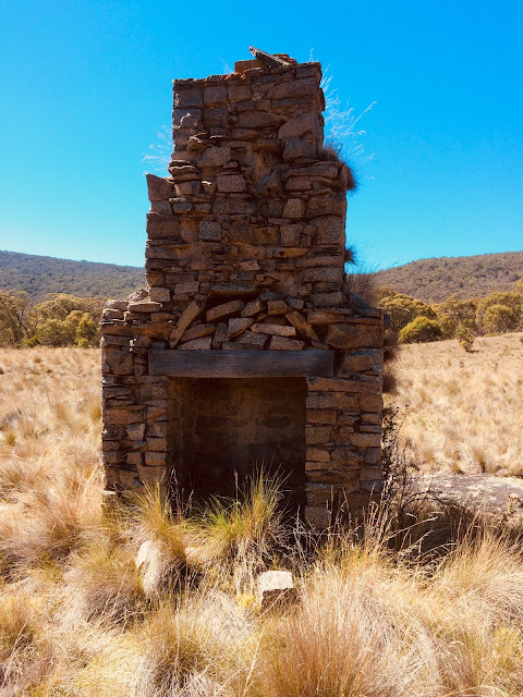
This walk started at the parking area near the Mt Clear Campground, just off Boboyan Road 50 kilometers south of Tharwa. We followed the Naas Valley Fire Trail for just a short distance until there is a trail off to the right leading to Webbs Dam. We passed to the east of the Dam and followed the western side of Grassy Creek until we reached Potter's Chimney, the last remnant of a nineteenth century settler's hut.

From there we continued up and across Grassy Creek and on to the Long Flat Fire Trail. We followed the trail up a fairly steep incline and then along a flatter straight section heading roughly southeast. There is a bend in the track at 55H FA 83654 25870 and we left it here to the right to find Sam Aboud's Dunny, an outdoor flushing toilet built here by Sam Aboud in the 1960s.

Sadly a large chunk of the pan has been broken away, but it's still one of the more interesting sights in Namadgi National Park.
From here we went back to the track and crossed the unnamed creek at 55H FA 83791 25966 and headed bush. Graeme Barrow gives the location of Chalker's Hut as 55H FA 84000 26300, and using my GPS we were able to find it quite easily in a quite pretty spot underneath Mt Clear.

There is little left of the hut - just a chimney and some stone foundations - but it is well worth the effort to get there.
Rather than return the way we came, we decided to head for map reference 55H FA 83146 27183 and follow the creek down a gully to the Naas Valley Fire Trail. The gully was initially easy going, but as the sides became steeper it became more difficult. Plenty of dense shrubs and rocks to navigate through. Following the creek itself was impossible, so we had to weave around up one side or the other, wherever the terrain looked easiest. Eventually we came to the Fire Trail which we followed back to the carpark.
This walk started at the parking area near the Mt Clear Campground, just off Boboyan Road 50 kilometers south of Tharwa. We followed the Naas Valley Fire Trail for just a short distance until there is a trail off to the right leading to Webbs Dam. We passed to the east of the Dam and followed the western side of Grassy Creek until we reached Potter's Chimney, the last remnant of a nineteenth century settler's hut.


Sadly a large chunk of the pan has been broken away, but it's still one of the more interesting sights in Namadgi National Park.
From here we went back to the track and crossed the unnamed creek at 55H FA 83791 25966 and headed bush. Graeme Barrow gives the location of Chalker's Hut as 55H FA 84000 26300, and using my GPS we were able to find it quite easily in a quite pretty spot underneath Mt Clear.

There is little left of the hut - just a chimney and some stone foundations - but it is well worth the effort to get there.

Rather than return the way we came, we decided to head for map reference 55H FA 83146 27183 and follow the creek down a gully to the Naas Valley Fire Trail. The gully was initially easy going, but as the sides became steeper it became more difficult. Plenty of dense shrubs and rocks to navigate through. Following the creek itself was impossible, so we had to weave around up one side or the other, wherever the terrain looked easiest. Eventually we came to the Fire Trail which we followed back to the carpark.
No comments:
Post a Comment