Saturday, 17 September 2016

Weddin Mountains National Park: Holy Camp to Ben Halls Camping Ground

General Information


Distance: 13.85 kilometers return
Total climb: 762 meters
Time taken: 3 hours 40 minutes
Maps:  Grenfell 8530-S 1:50 000; Marsden 8430-S 1:50 000
Guide:  link
Start point distance by road from Canberra GPO:  221 kilometers
Start point map grid reference:  55H EC 92712 48676 [Grenfell]
Destination map grid reference:  55H EC 88176 47986 [Marsden]
End point:  same as start


Route


http://maps.six.nsw.gov.au/

Description


The starting point for the hike was Holy Camp on the eastern edge of the National Park. Approaching from Grenfell, I drove Holy Camp Road for 14 kilometers until it ends at Holy Camp carpark. The first 10 kilometers of Holy Camp Road is sealed, although narrow, and possibly from what I saw flood-prone. The final 4 kilometers is gravel, and after the recent rain was in a pretty bad state. I had no difficulty getting through, albeit slowly, with a Honda CRV. I commenced hiking at 11:30am, following a clearly signposted and easy-to-follow track, with the Weddin Mountain Range looming above.


The track passes through open forest for 900 meters before striking the gully of an unnamed creek, where the track is a bit more difficult to follow, particularly where it goes over rocks.

About 600 meters elevation (200 meters above and 1.4 kilometers distance from the starting point), a short side-track takes hikers to the first vantage point on the ascent, Peregrine Lookout. There are some excellent views here to the north and east.


Continuing along the track up a steep climb for another 1.2 kilometers, there is eventually another short side-track leading to Eualdrie trig. At 733 meters elevation, Eualdrie also has excellent views to the north and east (though probably more spectacular in less overcast conditions).
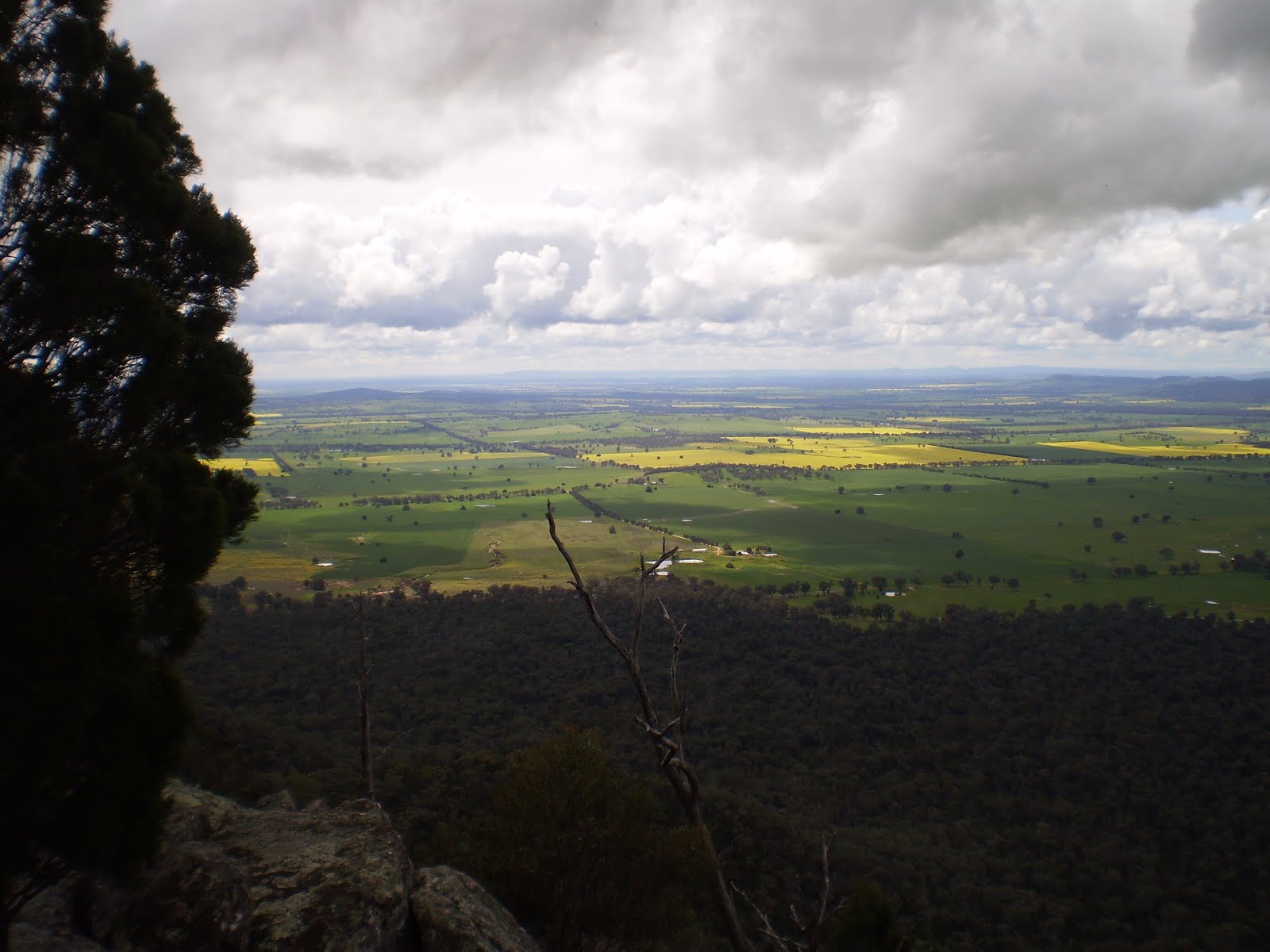
Returning to the main track, I headed roughly west through some scrubby and unappealing forest before striking Basin Gully at approximately 3.9 kilometers into the hike. At this point the track is often indistinct, and is best followed by looking out for round white reflectors nailed to trees and logs. Even so, I found myself pausing at several points before I could find the next reflector. The rest of the track follows Basin Gully, which becomes narrower and deeper as you descend.


At the time that I was hiking, there was plenty of water in the creek and, as the track crosses it many times, it became quite a challenge to stay dry. At some crossings I had to take a running leap to get over the creek, or look for rocks or trees step across. The wet rocks were treacherous, however, and at one point I found myself almost up to my knees in water after slipping in. In coming down the Gully there are occasional glimpses of farmland out to the west.


Only 300 meters short of Ben Halls Camping Ground I found a final wide, deep and fast-flowing creek crossing that I decided not to attempt, and started the hike back the way that I had come. Having descended to an elevation of 330 meters, it is a mildly taxing 400 meter climb over a 4 kilometre distance back to Eualdrie trig, followed by 320 meter decent over a 2.6 kilometre distance to get back to the carpark. Some feral goats were sighted in the gully below Peregrine Lookout.

The NSW National Parks rate the section from Holy Camp to Eualdrie trig as Grade 4 (Bushwalking experience recommended. Tracks may be long, rough and very steep. Directional signage may be limited.), and the section from Euraldrie trig to Ben Hall's Camping Ground as Grade 5 (Very experienced bushwalkers with specialised skills, including navigation and emergency first aid. Tracks are likely to be very rough, very steep and unmarked.). Their suggested time to do both of these sections and return is a very generous 5.5 to 7.5 hours. Although I completed the walk in 3 hours 40 minutes, I was probably quicker than I'd normally be because I was walking alone (which I never recommend!) and was on a tight deadline to get back to Cowra that afternoon. The hike was far more challenging than I had expected. Some sore muscles at the end of the day, but a lot of satisfaction too. In terms of aesthetics, some of the forest traversed is a bit unattractive, but the gullies and high vantage points (Peregrine and Euraldrie) more than compensate. It is well worth the effort if you happen to be in or passing through the area. The track is generally in good condition, even after all the rain, and its indistinctness through Basin Gully is a satisfying challenge.


An interesting postscript: Weddin Mountains National Park was closed due to "inclement and prevailing weather conditions" just two days after I completed this hike. At the time of posting it is not expected to reopen until 17 October 2016.

Saturday, 27 August 2016

Namadgi National Park: Corin Dam to Pryors Hut

General Information


Distance:  16.3 kilometers
Total climb:  1,053 meters
Time taken:  4 hours 23 minutes
Map:  Corin Dam 8626-1N 1:25 000
Guide:  none available
Start point distance by road from Canberra GPO:  60 kilometers
Start point map grid reference:  55H FA 66343 66173
Destination map grid reference:  55H FA 61153 63140
End point:  same as start


Route


http://maps.six.nsw.gov.au/

Description


The first two kilometers of the track is a series of very steep climbs taking you from an elevation of 950 meters to a little over 1400 meters. This is not a track for the unfit. There are many stairs on this section of the track which make walking safer, but seem to put a lot of pressure on the legs. There are limited vantage points along the track, which is well forested. The walk begins at the carpark at Corin Dam. Follow the signs at the end of the carpark to the start of the well-defined walking track. At the end of this first section is Stockyard Spur, where the terrain flattens and I saw the first scatterings of snow.


The snow became progressively thicker as I continued the climb until the ground was covered by crisp snow to a depth of around 15 centimeters. Luckily the track was still easy to distinguish thanks to the wheel ruts, and pesky GPS/map navigation was not necessary.


Along this section of track there were occasional views towards Mount Ginini to the northwest and Mount Gingera to the southwest. At the 1532 meter peak at map reference FA641654, about 3.5 kilometers into the walk, there were some spectacular views to the southeast.


The track climbs steadily until it meets the Mount Franklin Road, by which time about 7 kilometers has been travelled and an elevation of 1635 meters has been attained. Originally I was intending to leave the road at this point and ascend Little Ginini Mountain, but given the thick snow cover obscuring anything nasty that might lie underneath it I decided that it was probably not a safe choice. Instead I followed the Mount Franklin Road, which had been cleared of snow, south for 1 kilometer to Pryors Hut.


After all of this walking I was rather disappointed to find that the dunny behind the Hut had been closed until further notice, and I had to find a tree instead. Nevertheless, I took advantage of the Hut itself to have a reasonably comfortable lunch break before heading back the way that I had come. The return hike was highly enjoyable up to the two-kilometer descent back to Corin Dam where the steep slope and relentless steps caused some niggling joint pain in the legs until I got back to level ground.

This is a very demanding track, but with lots of rewards, even if it's just the achievement of getting up to Stockyard Spur. The snow at the higher parts of the trail added considerably to the beauty of the area and did not impede the hike in any way. This may be different when the snow is deeper and the track obscured. At the top of the track, where it meets the Mount Franklin Road, there are options to climb Mount Ginini to the north or Mount Gingera to the south. Two hikers I met on the return journey were in fact climbing up to Mount Gingera to spend the night there camping in the snow.

Thursday, 18 August 2016

Bullen Nature Reserve: Cotter Reserve to Bullen Hill and Pierces Creek Pine Forest

General Information


Distance:  normally 16.5 kilometers, but I walked close to 18 kilometers due to some exploring and backtracking
Total climb:  652 meters
Time taken:  4 hours
Map:  Cotter Dam 8627-2N 1:25 000
Guide:  none available
Start point distance by road from Canberra GPO:  24 kilometers
Start point map grid reference:  55H FA 76314 89207
Destination map grid reference:  55H FA 78819 85130
End point:  same as start


Route


http://maps.six.nsw.gov.au/

Description


The starting point for this hike was the Cotter Reserve carpark on the left just over the Cotter River bridge (for readers familiar with the pre-2003 bushfire Cotter Reserve, this is where the old Cotter Pub used to be). I started the hike at 8:30am. From the carpark I followed the Cotter Discovery Trail southwest around the bend in the Cotter River until the trail meets a management road. I followed this management road to the left, taking a brief side-trip to Cotter Cave (not open to the public), before eventually swinging round to the northeast to a ford over Paddys River. I looked both upstream and downstream for possible rock-hopping crossings, but none were to be found. This left the ford itself as the only possible crossing, so it was shoes off and across the shin-deep icy water. Across the ford, I followed the management trail around and up the northern extremity of the Bullen Range. This offered some reasonably good views back towards the Cotter Reserve and Cotter Dam.


From this point, the trail follows the top of the Bullen Range up and down various peaks. There are occasional views to the northeast and southwest, but the forest is usually quite dense and restricts visibility. About 5.5 kilometers into the walk the trail meets pine forest on the right, and from here it is only 1.5 kilometers to the base of Bullen Hill. When I arrived at Bullen Hill, I walked directly up a steep and treacherous track (I suspect used mainly by dirt bikers) to the summit.


I later found that had I followed the main trail around the the west of Bullen Hill, there is a much easier climb to the summit from the south. Bullen Hill at 757 meters elevation has some good views in most directions.


After pausing for a coffee on the summit, I descended back to the management trail and retraced my steps northwards. At map reference FA789857 I followed another management trail west into Pierces Creek Pine Forest. From here I followed various management trails westwards towards Paddys River, which I hoped to be able to cross. Unfortunately, the banks of the river where I struck it were fairly thick with blackberry bushes and there were no obvious shallow crossing points, so I headed south towards the ford at the Murray's Corner picnic area - another boots-off crossing of Paddys River in shin-deep freezing water. Following Paddys River Road north for just under a kilometre, I re-entered the pine forest east of Paddys River Road via the management trail at FA768853. From here it was a matter of navigating the maze of fire trails back to the Cotter Discovery Trail. As with most walks through pine forests, there was little to see other than pine trees. Near the end, however, there were some nice views above the Cotter Reserve.


The road seen in the distance in this photograph is the management trail up the northern end of Bullen Range where I started the climb.

This was a fairly easy walk, mostly along management trails, but with some steep sections and a reasonable amount of climbing (the starting point at around 480 meters elevation is less than 300 meters below the high point at Bullen Hill, but there is a lot of up-and-down track). The two barefoot river crossings were only a slight nuisance, mostly because the water was so cold. The views from the ridge are good, without being spectacular. Navigating through the pine forest requires some concentration and a decent map, and while there is not much to see in a pine forest there are some nice features along the way. Having done this section of Bullen Range, I'm considering a future walk along the full Bullen Range from Tidbinbilla Road to the Cotter Reserve (about 21 kilometers).

Saturday, 13 August 2016

Tidbinbilla Nature Reserve: Mount Domain (1)

General Information


Distance:  13 kilometers
Total climb:  759 meters
Time taken:  4 hours 7 minutes
Map:  Tidbinbilla 8627-2S, 1:25 000
Guide:  none available
Start point distance by road from Canberra GPO:  50 kilometers
Start point map grid reference:  55H FA 72311 71964
Destination map grid reference:  55H FA 69661 72739
End point:  same as start


Route


http://maps.six.nsw.gov.au/

Description


This hike starts at the Fishing Gap Carpark off the Tidbinbilla Loop Road. I commenced the hike at 9:30am, signing into the Hikers Register near the gate on Fishing Gap Road. 
The first section of the hike follows the Fishing Gap Road for 4 kilometers until its end at Fishing Gap itself. This is a pleasant and easy walk along a wide fire trail through thick forest, gaining about 300 meters of elevation from start to end. At Fishing Gap there is a track cut through the new growth to the north which is the start of the track to Mount Domain. At first the track is relatively easy to follow by looking for saplings that have been cut down to clear the way, but eventually this gets to a clearing where the cut trail ends.


From here it is necessary to follow a trail through the scrub marked by pink ribbon tied to trees. Finding these requires paying attention and sometimes pausing to look for the next ribbon. The scrub is very dense in places, and I came out of it with numerous rips in the woollen jumper I was wearing. Some more patience on my part would probably have avoided most if not all of them.


It was about 2.5 kilometers from Fishing Gap to the summit of Mount Domain, but with difficult terrain and a 380 meter climb it took well over an hour to complete this short section. There are excellent views from the top of Mount Domain in all directions.


At just over 1500 meters elevation, and with a strong wing blowing from the west, it was very cold indeed on the summit. I returned the same way that I had come. The downhill section from Mount Domain to Fishing Gap proved to be equally difficult to navigate through, and footing in some areas was quite treacherous. I only fell flat on my butt the once, but it gave me a few bruises to remember it all. It was with some relief that I got back on to the Fishing Gap Road for an easy descent back to the carpark.

Regrowth of trees following the 2003 bushfires presents some challenges for hiking in the Tidbinbilla Range once you get off the fire trails and manicured walking trails. In many ways this hike took me back to an ascent of nearby Tidbinbilla Peak in 2015 where I had to fight through 1.5 kilometers of thick tangles of saplings as soon as I stepped off the Tidbinbilla Range Road. While this can be satisfying at the end, it takes a lot of time and energy. Nevertheless, Mount Domain was a very enjoyable hike. The more people that follow the trail up to the top, the more defined and easy it will be in the future.

Sunday, 7 August 2016

Namadgi National Park: Mount Tennent (2)

General Information


Distance:  15.7 kilometers return
Total climb:  899 meters
Time taken:  4 hours 10 minutes
Map:  Williamsdale 8726-4N, 1:25 000
Guide:   link
Start point distance by road from Canberra GPO:  36 kilometers
Start point map grid reference:  55H FA 87286 66083
Destination map grid reference:  55H FA 85340 64040
End point:  same as start
Note: I had previously done this walk on 2 April 2016 in far better weather, so I have used photographs from this earlier walk.


Route


http://maps.six.nsw.gov.au/

Description


This hike follows part of the Australian Alps Walking Track (AAWT), which begins at the Namadgi Visitor Centre, as does this particular hike. The Visitor Centre is on Naas Road 2.5 kilometers south of the village of Tharwa. From the Visitor Centre carpark, the first part of the trail leads back to Naas Road about 500 meters southwest of the carpark entry. We crossed the road and continued the trail on the other side, having first entered our intentions on the walkers' register there. The track climbs fairly gently at first, but starts to get steeper. About 2.8 kilometers from the start, having climbed about 170 meters, Cypress Pine Lookout offers some good views over the valley of the Murrumbidgee River to the east.


About 2.3 kilometers from Cypress Pine Lookout, the track forks, with the AAWT continuing to the right, and another trail to Mount Tennent heading left, which is the one that we wanted. This is well signposted, so does not present any difficulties. [Note: The Williamsdale map shows no fork in the track and has the AAWT following the track to Mount Tennent. There was a rerouting of the AAWT into the valley west of Mount Tennent and this has yet to find its way onto the printed map.]

Continuing along the  track, after 1.3 kilometers we struck the Mount Tennent Fire Trail and continued uphill. The Fire Trail leg of the hike is only about 1.2 kilometres long, but climbs about 160 meters in elevation, so very steep in most places. It is quite a relief to get to the summit, where there are great views in most directions. Or at least there are in good weather - we found ourselves up in the clouds on this particular day, but on a good day:


We returned the same way we came up, but it is also possible to continue down the Mount Tennent Fire Trail until it meets Apollo Road. This would require, however, either someone to pick you up at that end, or a long walk of over 10 kilometers back up Naas Road to the Namadgi Visitor Centre.

Make no mistake, this is quite a climb, but a very rewarding one. It can be quite busy on weekends, so if you are the type of hiker who likes peace and solitude it's best to go on a weekday if you can. The track is easy to follow and quite well maintained. On a good day, the views are spectacular, but if there is cloud and rain about it's probably best to leave it for another time. 

Thursday, 4 August 2016

Kowen Pine Forest: Mount Cohen, Amungula and Glen Burn Homestead

General Information


Distance:  19.5 kilometers
Total climb:  570 meters
Time taken:  5 hours 10 minutes
Map:  Bungendore 8727-2N, 1:25 000
Guide:  none available
Start point distance by road from Canberra GPO:  26 kilometers
Start point map grid reference:  55H GA 13682 88573
Destination map grid references:  Mount Cohen - 55H GA 12899 91821
                                                      Amungula - 55HGA 11129 9261
                                                      Glen Burn Homestead - 55H GA 10374 90389
End point: same as start


Route


http://maps.six.nsw.gov.au/

Description


The starting point for the hike was the gate at the end of Sparrow Hill Road, which comes off the Kings Highway just after Burbong. From here we entered the Kowen Pine Forest and followed management trails in a general northerly direction until we reached Mount Cohen, a peak at 918 meters elevation which is thick with tall pine trees and did not offer any views.


After a coffee break, we followed fire trails in a general westerly direction to the top of Amungula at 915 meters elevation. There were some views north towards Wamboin just before we reached the summit.


From Amungula we followed management trails south through the pine forest until we came to Glen Burn Homestead, where we took the opportunity to look at the homestead and nearby pioneer graves.


From the gravesite we headed east through very boggy ground to get back into the pine forest with the intention of following management trails east to out starting point. Unfortunately we were blocked by a large area of recent logging activity which we were prohibited from entering. As a result, we ended up on Charcoal Kiln Road, which we followed down to Sparrow Hill Road. We started slogging our way up Sparrow Hill Road to get back to the car, but luckily my hiking companion started up a conversation with a passing motorist who kindly drove us the remaining way.

This is an easy and quite pleasant walk through pine forest, but without any particularly interesting views. The Kowen Pine Forest itself, however, is quiet and not without its nice spots, although obviously the areas that have been logged (and we passed by or through a few of these) are pretty awful. The highlight of the hike for me was Glen Burn Homestead, which can be visited also by driving up Charcoal Kiln Road (gravel). Navigating through pine forest requires a good map and compass to make the right route choices.

Thursday, 28 July 2016

Tinderry Nature Reserve: Tinderry Peak (1)

General Information


Distance:  16.8 kilometers
Total climb:  767 meters
Time taken:  6 hours 20 minutes
Map:  Tinderry 8726-1S, 1:25 000
Guide:  none available
Start point distance by road from Canberra GPO:  72 kilometers
Starting point map grid reference:  55H GA 06863 43178
Destination map grid reference:  55H GA 05525 47202 [not achieved]
End point:  same as start


Route


http://maps.six.nsw.gov.au/

Description


The starting point for the hike was the small carpark off Tinderry Road where it meets the Round Flat Fire Trail,15 kilometers east of Michelago. We set out by following the Round Flat Fire Trail until it intersects with the East Tinderry Fire Trail, just over 3 kilometers into the hike. We followed the East Tinderry Fire Trail north for another 2.5 kilometers.


At a slight kink in the Trail at map reference GA802470, we walked due east through the bush until we met a minor road leading on the right to a pig trap at map reference GA073471. From the pig trap we followed Groggy Creek after it bends to the northwest to its source, but eventually left the creek travelling southwest to try to locate a spot to the south of Tinderry Peak itself where, based on other bushwalker accounts, we could climb to the summit. This is where we came unstuck, finding ourselves in the maze of rocks around map reference GA595471 only a few hundred meters from Tinderry Peak which we could see clearly.


Having had a fairly late start to the hike we were running out of time, so to be sure of getting back before dark we decided to head back and leave the Peak for another day. Initially we hiked in an easterly direction where we found a large rock platform around map reference GA066471 which offered an excellent view to the east.


Since the rock shelf ended in a high cliff to the east, we turned north until we cleared the rocks and using the GPS which I had programmed with the coordinates earlier, made our way back to the pig trap. From there we followed the small side track which actually took us all the way back to the East Tinderry Fire Trail just a bit south of where we left it on the way up. We then retraced our steps down the East Tinderry and Round Flat Fire Trails to the carpark.

While it was disappointing not to reach Tinderry Peak, we had taken the safe option to ensure we didn't get caught out on the track after sunset. At least this failure gives us a reason for doing it all again. Next time we may try another route: Round Flat Fire Trail until it bends sharply east; then north through the bush until Roberts Creek; then follow Roberts Creek to just south of Tinderry Peak; then climb the Peak from the south. Overall, however, this was a very good hike with a nice mix of fire trails and bush-bashing; an opportunity to use map/GPS navigation skills rather than just following someone else's trail. The forest is thick, but reasonably easy to pass through. The rock outcrops which scatter throughout the area make navigation more difficult, and we probably should have paid more attention to the map and GPS as we were ascending to avoid these.


Saturday, 23 July 2016

Canberra Nature Park: One Tree Hill (2)

General Information


Distance: 7.2 kilometers return
Total climb: 232 meters
Time taken: 1 hour 50 minutes
Map:  Hall 8727-4S, 1:25 000
Guide:  ACT Centenary Trail - link
Start point distance by road from Canberra GPO:  15 kilometers
Start point map grid reference:  55H FB 88578 06552
Destination map grid reference:  55H FB 90528 09191
End point:  same as start


Route


http://maps.six.nsw.gov.au/

Description


This is a short and very easy hike along a small section of the Centenary Trail. The starting point is the northern corner of Hall Village, where Hoskins Street meets Hall Street. Some on-road car parking is available here, and the start of the trail is well signposted. The trail starts on a gated vehicular track which leads up to a water reservoir above Hall Village. From here it narrows to a walking track which hugs the eastern side of the small range which includes One Tree Hill. There are views of residual farmland in the early part of the trail with the city and older suburbs of Canberra in the background.


As elevation is gained the view starts to be dominated by the new suburbs of Gungahlin. Construction noise can sometimes be heard, which detracts from the walking experience a bit, but is only temporary. There are still some good rural views towards the north as the trail continues.


About 2.5 kilometers along the main trail there is a signposted minor track off to the left which leads to the summit of One Tree Hill. This side track is approximately 1 kilometre in length and climbs about 55 metres in elevation. There are around 200 steps to climb, so this is by far the most strenuous part of the hike. One Tree Hill is 855 metres elevation, making it higher than both Black Mountain and Mount Ainslie. One Tree Hill is right on the ACT/NSW border, and is in fact the north-eastern end of the only straight line in the ACT/NSW border (the other end being at Mount Coree). There are views in all directions, although somewhat blocked to the west by a fire tower. At the summit there is a welcome seat to admire the view, and a panoramic photograph pointing out some of the features visible from there.


The return hike was by the same route.

This is my favourite short walk around Canberra, but it can also be included in longer walks that follow the Centenary Trail.


Thursday, 7 July 2016

Canberra Nature Park: Black Mountain

General Information


Distance:  8.7 kilometers
Total climb:  about 300 meters
Time taken:  about 2 hours
Map:  Canberra 8727-3N, 1:25 000
Guide:  link
Start point distance by road from Canberra GPO:  6 kilometers
Start point map grid reference:  55H FA 89742 94003
Destination map grid reference:  55H FA 90795 94553
End point:  same as start


Route


http://maps.six.nsw.gov.au/

Description


There are a number of possible starting points for walking around Black Mountain, but I used the carpark off William Hovell Drive near Glenloch Interchange. From here I first walked south along the cycle path until I came to a track on the left with a gate. I followed this track to the east and then north, gradually climbing until I came to the track at map grid reference 55H FA 90818 95033 which leads up to the summit of Black Mountain. Reaching the Summit after a hefty climb. I then descended to the ring trail that goes around the Mountain at roughly 750 meters elevation. Following the ring trail I came to the carpark off Black Mountain Drive at map grid reference 55H FA 90848 94130 and from here walked down Black Mountain Drive to a gated track at map grid reference 55H FA 90781 93755. There were some good views towards Lake Burley Griffin and Scrivener Dam from this track.


I followed the track back to the gate off the cycle path and returned to my car.

Black Mountain has a large number of excellent trails and is perfect for just exploring. I found some of the traffic noise on the western side a bit distracting, but the bushland is very pretty.