Saturday, 7 December 2019

Tidbinbilla Nature Reserve: Tidbinbilla Mountain

General Information

Grading: hard
Distance:  7.3 kilometers 
Total climb:  640 meters 
Time taken:  4 hours 45 minutes 
Map:  Tidbinbilla 8627-2S, 1:25 000 
Start point distance by road from Canberra GPO:  52 kilometers 
Start point map grid reference:  55H FA 71471 74628 
Destination map grid reference:  55H FA 69509 75951 
End point:  same as start

Route

http://maps.six.nsw.gov.au/

Description

This walk started at the Mountain Creek carpark in the Tidbinbilla Nature Reserve. We started by walking up the Camelback Firetrail and then on to the Lyrebird Trail, which we followed up to a point at grid reference 55H FA 70938 74643. Here there is an indistinct and unmarked foot track on the right. This started us on a long, uphill climb by a fairly direct route to Tidbinbilla Mountain.

The first point of note on the climb was at around 1240 meters elevation where there is a small lookout with a couple of benches. This gave some views back into the Tidbinbilla Valley...

... and towards Mt Domain.

Having taken a break there, we continued up another 200 meters in elevation where the track flattens and veers right towards Snowy Corner. Walking along the track here we had our first real glimpse of our destination. We also encountered the first of two snakes (either a Brown or a Tiger - who can tell?) sunning themselves on the track. After a brief stand-off while we glared at each other, the snake eventually slithered off when we started to move around to pass it.

From Snowy Corner the track curves around to the left up the ridge to the top of the mountain. Maybe only 50 meters from the summit we found the second snake, in this case almost certainly a Brown, with the same result: a staring competition followed by a reluctant serpentine retreat. Near the summit there was a clearing with some wildflowers still in bloom.

The summit of Tidbinbilla Mountain gives unobstructed views all around.

After a lunch break on the summit we headed back down the foot track, being particularly careful in the areas where we had seen the snakes (I had recorded these places on my GPS navigator). Luckily they were nowhere to be seen. After a steep, and in some places treacherous descent we made it back to the Lyrebird Trail (although there was an inevitable navigation error just before we reached it). Just for a bit of variety we went down the un-walked section of the Lyrebird Trail back to the carpark.

Tuesday, 10 September 2019

Uriarra: Sherwood Daffodils (1)

General Information

Grading: easy
Distance:   7.5 kilometers
Total climb:   207 meters
Time taken:   1 hour 45 minutes
Maps:   Cotter Dam 8627-2N 1:25 000
Start point distance by road from Canberra GPO:   32 kilometers
Start point map grid reference:  55H FA 74137 95543
Destination map grid reference:   55H FA 72104 95061
End point:  Same as start

Route


http://maps.six.nsw.gov.au/

Description

This walk started at a small carpark just off Mountain Creek Road 1.5 kilometres north of Uriarra Road. Proceeding through the gate, we followed a management trail roughly southwest for 2.5 kilometres before turning north through a rather nice open field which was once the site of the Sherwood Homestead.


After a short time we could see on the right the daffodils first planted by the Phillips family who settled there in 1863.


While there were a considerable number of flowers visible, I suspect that it will be a much more spectacular show in a few weeks' time.

We then walked back to the road and up a slight rise to the site of the graves of three members of the Phillips family. From there we returned the way that we came.

Tuesday, 20 August 2019

Canberra Nature Park: Wanniassa Ridge and Macarthur Hill

General Information

Grading:  easy
Distance:   7 kilometers
Total climb:   290 meters
Time taken:   2 hours
Maps:   Tuggeranong 8727-3S 1:25 000
Start point distance by road from Canberra GPO:   22 kilometers
Start point map grid reference:  55H FA 93399 80372
Destination map grid reference:   Mt Wanniassa 55H FA 92096 81476
                                                     Macarthur Hill 55H FA 92852 79816
End point:  Same as start

Route


http://maps.six.nsw.gov.au/

Description

This walk started at the northernmost point of Jackie Howe Crescent in Macarthur. We followed the vehicular trail north and then west to the water tank at map reference 55H FA 93207 80663, at which point we followed a walking track up to the top of the ridge. We continued along the vehicular trail along the top of the Wanniassa Ridge until we came to Mt Wanniassa itself. At an elevation of 890 metres, this gave us some good urban and rural views in most directions.

We backtracked along the ridge and this time followed the vehicular trail dow the ridge towards Macarthur Hill, which we eventually came to.

We walked down the hill and along Jackie Howe Crescent back to the car.

Friday, 16 August 2019

Tallaganda State Forest: Serenity Rocks and Mt Lowden

General Information

Grading: hard
Distance:   14 kilometers
Total climb:   750 meters
Time taken:   4 hours 45 minutes
Maps:   Bombay 8827-3S 1:25 000; Bendoura 8826-4N 1:25 000
Start point distance by road from Canberra GPO:   58 kilometers
Start point map grid reference:  55H GA 31672 67521
Destination map grid reference:   Serenity Rocks 55H GA 32965 69372
                                                     Mt Lowden Communications Tower 55H GA 33596 68115
End point:  Same as start

Route


http://maps.six.nsw.gov.au/

Description

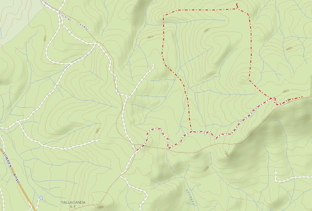
This walk Started at the intersection of the Bald Hill and Lowden Trig Fire Trails, about 2.7 kilometers up the Lowden Hill Fire Trail from Lowden Road. We walked along Lowden Road looking for a foot track off to the left which we found at map reference 55H GA 32368 67765.

We followed this track through some very pretty forest down into gullies formed by tributaries of Mulloon Creek. The tributaries, which we had to cross several times, were lined with beautiful tree ferns.

The track finally started taking us back uphill and we continued right up to the side track of the Bald Hill Fire Trail at map reference 55H GA 31916 68585 before we decided that we were no longer going in the right direction. Backtracking down to the creek, we found a side trail heading north (map reference 55H GA 32037 68584) which we had failed to see on the way up because it was obscured by a fallen tree. This track, which seems to have mainly been used by trail bikes, took us all the way round to the informally named Serenity Rocks (map reference 55H GA 32965 69372). The rocks are about 100 meters off the track and look like this:


The rocks give an excellent platform for views north to Mt Palerang.


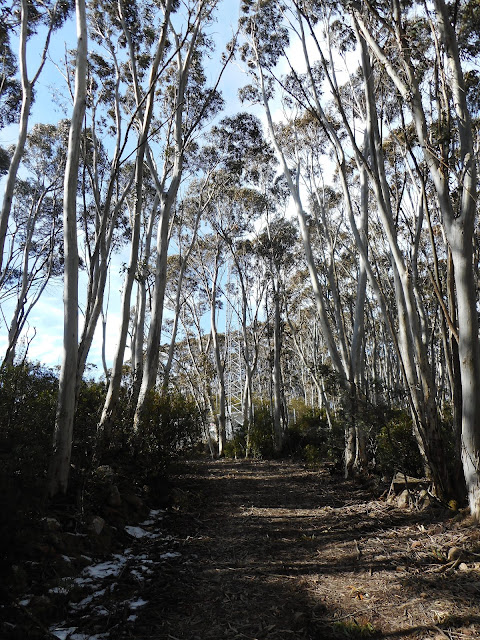
Going back to the walking/trail biking track, we started to head towards Mt Lowden. Pretty soon, however, we decided that the track was not taking us in the right direction, so we had to go bush and follow a bearing towards the Mt Lowden communications tower. While this was only a bit over a kilometre away, the dense scrub and occasional lawyer vines made it hard going. After about an hour-an-a-half of this slogging we finally made it back to the Lowden Hill Fire Trail, where at about 1300 meters there was still some of last week's snow in sheltered areas. From here it was only a short walk to the communications tower.


We continued past the communications tower thinking to reach the top of Mt Lowden about 600 metres distant. Again encountering thick scrub on the top of the ridge, however, we decided that it would take too much time and returned to the car via the Lowden Hill Fire Trail.

Thursday, 1 August 2019

Canberra Nature Park: National Arboretum and Barrer Hill

General Information

Grading:  easy
Distance:   14.7 kilometers
Total climb:   341 meters
Time taken:   3 hours 55 minutes
Maps:   Canberra 8627-3N 1:25 000
Guide:  Link
Start point distance by road from Canberra GPO:   6 kilometers
Start point map grid reference:  55H FA 89657 94097
Destination map grid reference:  55H FA 86272 90941
End point:  same as start

Route


http://maps.six.nsw.gov.au/

Description

This walk started from the Aranda Snow Gums carpark just off William Hovell Drive at Glenloch Interchange. We followed the cycle path and passed under William Hovell Drive into the cork oak plantation in the National Arboretum.

Making our way through the cork oaks and the Himalayan cedar forest...

...we made our way to Boundary Road which we followed west and then south until we came to the southern edge of the Arboretum near Tuggeranong Parkway. We continued south until we came to Barrer Hill, which will probably look a lot nicer when the revegetation takes hold.

We followed the trail to the left up to the summit of the hill, which has good 360 degree views.

Heading back into the Arboretum we followed River Road paralleling Tuggeranong Parkway for a while before heading off through the tree plantations towards the Village Centre cafe and a well-earned lunch. We then headed back to the carpark.


Tuesday, 30 July 2019

Stromlo Forest: Brown Hill

General Information

Grading:  easy
Distance:   10.8 kilometers
Total climb:   266 meters
Time taken:   2 hours  25 minutes
Maps:   Canberra 8727-3N 1:25 000
             Cotter Dam 8627-2N 1:25 000
Start point distance by road from Canberra GPO:   17 kilometers
Start point map grid reference:  Canberra 55H FA 82106 92209
Destination map grid reference:  Cotter Dam 55H FA 80526 88953
End point:  same as start

This was the second time I had done this walk, the first being on 16 October 2018.

Route

http://maps.six.nsw.gov.au/

Description

This walk commenced at a small parking area at the western edge of Stromlo Forest just off Uriarra Road. We followed the unnamed management trail to the southwest and then south, generally keeping to the right when we came to a fork in the trail. The walking is pretty gentle, with a few creek crossings and a generally open aspect. I had my first sighting of the snake season, with a red-bellied black snake watching me alertly from the side of the track. There were also some particularly nice views over toward Cotter Dam along the trail.


Reaching Brown Hill we followed the trail east and then turned off onto the rough track to the summit. There are excellent 360 degree views from there.


Rather than returning the same way, we continued down the hill in an easterly direction before taking another trail to the north.

Thursday, 18 July 2019

Cairns Region: Cattana Wetlands Jabiru Lake Circuit

General Information

Grading: very easy
Distance:   1.5 kilometers
Total climb:   negligible
Time taken:   20 minutes
Start point distance by road from Cairns PO:   17 kilometers

Route

Cairns Regional Council

Description

This was a very short walk which we were able to fit in with a day's sightseeing around Cairns. It started from the Cattana Wetlands carpark off Dunne Road, Smithfield. With limited time we chose to do the loop around Jabiru Lake. The surface was flat and paved, making for easy walking and plenty of time to take in the wetlands and its birdlife.

Tuesday, 16 July 2019

Cairns Region: Earl Hill Summit Track

General Information

Grading:  easy
Distance:   3 kilometers
Total climb:   210 meters
Time taken:   1 hour
Start point distance by road from Cairns PO:   19 kilometers
End point:  same as start

Route

http://qtopo.dnrm.qld.gov.au

Description

This walk started from the carpark in Reed Road, Trinity Beach, just before the roundabout intersection with Roberts Drive. From here it is about a 350 metre walk to the start of the Earl Hill summit walking track in Roberts Drive.

The walking track is clear, well-maintained and well-used, although some sections are quite steep.

The track follows the ridge south southeast of the summit, where there are some views of Trinity Beach to the north...

...and back towards the coastline towards Cairns itself to the south.

I walked back to the car the same way.


Wednesday, 10 July 2019

Cairns Region: Mount Whitfield Conservation Park

General Information

Grading:  easy
Distance:   9 kilometers
Total climb:   350 meters (approximate)
Time taken:   2 hours
Start point distance by road from Canberra GPO:   2,517 kilometers (but only 4 kilometers 
                                                                                 from Cairns Post Office)
Start point:  Red Arrow Walking Track off Collins Avenue, Edge Hill
Destination:  Mount Whitfield (364 meters)
End point:  same as start

Route

Cairns Regional Council

Description

Having parked my car along Collins Avenue, not far from Sheridan Street, I started up the beautifully maintained bitumen Red Arrow Walking Track. Coming to the junction where the Red Arrow loops around, I took the right hand fork which led me through thick rainforest and at one point a bamboo thicket.

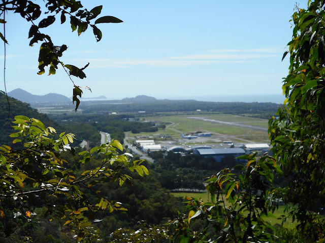
After some heavy climbing I came to a lookout which gave some views northeast towards Cairns Airport and the ocean.

Soon after this point I came to the junction of the Red Arrow and Blue Arrow tracks and followed the Blue Arrow, leaving smooth bitumen for a narrow dirt track crisscrossed with tangled roots providing an excellent tripping hazard.

Coming to a junction where the Blue Arrow loops around, I followed the left hand track and continued climbing through the rainforest until I came to the intersection of the Blue Arrow and Green Arrow tracks. I followed the Green Arrow a short distance up to Mt Whitfield, which I possibly would have missed had it not been for a sign telling me I had arrived.

There are no views from Mt Whitfield, but the star of this walk is more the rainforest than the elevation.

Running a bit short of timeI quickly retraced my steps back along the Green and Blue Arrows to the Red Arrow. I turned right at the Red Arrow to take me down the un-walked section back to the parked car.